|
Notes: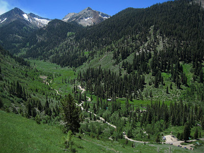
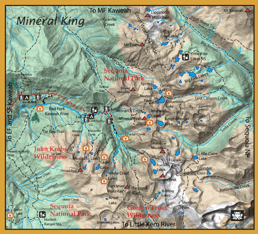
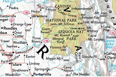
Mineral King is within a glacial valley known as the White Chief Valley and was discovered by propsectors in the 1880's to contain silver. However, the winter avalanches and poor ore, kept the miners from being profitable. The beauty of the area was the attraction and cabin sites were built in the early 1900's at Cabin Cove, Faculty Flats, and Mineral King. Walt Disney Corp wanted to build a ski resort here in the 1960's and 70's. After much debate, Congress included Mineral King into Sequoia National Park in 1978 and protected the valley from further development. The Mineral King area consists of many small lakes with primarily Brookies in the 7-10 inch class. Some lakes contain Rainbows where sufficient spawning tributaries exist. The EF Kaweah flows through the Mineral King Valley from White Chief Lake and into a canyon below Faculty Flats Falls. The section of the river below the falls contain both rainbows and browns in the 7-10 inch range. The section above the falls is a relatively flat section with shallow pools and a meandering course. This section has rainbows and Golden-hybrids. CDFW Records from 1910 indicate that Little Kern Goldens were planted within this section. These fish have hybridized with introduced Rainbows so the fish have a very variable appearance. Some still have distinct Golden markings. The season is the last Saturday in April to November 15th, although access to the area is often restricted due to snow until mid-June.
Atwell Mill is the first of two campgrounds
with 25 sites, at 18.7 miles. The campground is located above the site of a defunct sawmill. You can see the remains of the mill’s large steam engine near some giant sequoia stumps in a clearing across from the Atwell Mill Ranger residence. Between campsites 16 and 17 is the beginning of the Atwell-Hockett Trail.The trail descends past the site of the old sawmill and then through forest to a scenic bridge crossing the East Fork Kaweah River. This will give you access to the river section. The river is a freestone stream with plenty of boulders and plunge pools. Both rainbow and browns reside here. There is no river trail, so you have to boulder hop either upstream or downstream.
Just before reaching the Silver City Resort (19.9 miles) you will pass Cabin Cove, a group of six summer cabins. Silver City Resort rents out cabins and chalets and includes a small restaurant and tiny store. Just beyond Silver City Resort is Faculty Flats, a summer community of about 30 cabins, at 22.3 miles. The cabins were built in the 1920’s and many are on the National Register of Historic Places. About a half mile further up the road is the Mineral King Ranger Station and the Cold Springs campground (40 sites). Continuing up the road you will pass the Tar Gap parking area, the Sawtooth / Monarch Lake trailhead parking areas and a number of cabins before reaching the end of the road at 23.5 miles. At the end of the road is the start of the Eagle Lake, Mosquito Lake and White Chief Canyon trails. A short distance back down the road is the beginning of the Farewell Gap and trails. Around the trailhead parking area is another group of 24 summer cabins, referred to as East Mineral King or the Beulah Tract.
At the Tar Gap parking lot next to the Mineral King Ranger Station is access to the EF Kaweah above the canyon falls. The water is a freestone stream with plunge pools near the ranger station. The trail goes to the southwest around the Tar Gap mountain and then heads southeast going past Clover and Corner Creek. Once at Horse Creek, you can follow Horse creek off-trail upstream to Ansel Lake.
Ansel Lake: Elevation 10,500 feet. Consists of Rainbows. A distance of 10.7 miles from the trailhead with an elevation gain of 3,016 feet.
The Tar Gap trailhead continues onto the Hockett ranger station and a westerly spur trail goes to Evelyn Lake which contain Brookies 8-9 inches.
The next trailhead is the parking lot for the Sawtooth Pass trail. The first lake along this trail is Monarch Lake.
Monarch Lakes: Two lakes; Upper Monarch at 10,375 feet with Brookies and Lower Monarch at 10,350 with Rainbows and Brookies. The trailhead is at Mineral King with a distance of 3.0 miles and a 2549 feet gain.The Sawtooth Pass trail also provides access to two excellent Brookies lakes:
Columbine Lake: (10,970'ele.) This lake is known for a good population of Brookies, 7-10". It lies within a granite basin about 560' below Sawtooth Pass but deep enough to not totally freeze during winter.
Cyclamen Lake: (10,478' ele.) This lake is just north of Columbine but is 500' lower than Colmbine over a 1/4 mile distance. The access is a steep descent. This lake is similar to Columbine with another healthy population of Brookies.
The trail continues down into Lost Canyon and onto the Big Arroyo.
The final trailhead is from the parking lot at the end of the road. This trailhead provides access to three trails going to the Mosquito Lakes, Eagle Lake, and White Chief Canyon.The trail to Mosquito Lakes spurs off the Eagle Lake Trail at 1.75 miles. It continues another 1.4 miles around Miners Ridge to the first lake.
Mosquito Lake no. 1: Elevation 8950 feet (4.5 acres) Eleven feet deep, this lake is in a glacial granitoid cirque, 3.25 miles from the trailhead with a 1239 feet gain. Consists of Brookies.
Mosquito Lake no.2: Elevation 9580 feet (6 acres) 26 feet deep within a rocky, wooded, glacial basin. This is the only lake within the group with both rainbows and brookies. 4 miles from the trailhead.
Mosquito Lake no.3: Elevation 9825 feet (1 acre) only 9 feet deep and subject to winter kill from freezing. This lake is naturally restocked by the Brookies from Mosquito Lake no. 4. 4.4 miles from the trailhead
Mosquito Lake no. 4: Elevation 9925 feet (4 acres) 16 feet deep as a granitoid glaciated bench lake with good spawning habitat. 4.75 miles from the trailhead. Consists of Brookies.
Mosquito Lake no.5: Elevation 10,040 feet (10 acres) Possibly 25 feet deep, an open granitoid cirque lake just below timberline with a partial turfy meadow around it's fringe. Must go off-trail from Mosquito Lake no. 4. 5 miles from the trailhead. Consists of Brookies with good food source and spawning.
Continuing on the Eagle Lake Trail, past the Mosquito Trail spur, you can reach Eagle Lake at 3.0 miles from the trailhead.
Eagle Lake: Elevation 10,000 feet. (12 acres) 39 feet deep, high granitoid glacial lake. Fair spawning and good food productivity. Consists of Brookies 7-10 inches. The trailhead is at Mineral King with a 3.0 mile distance and a 2200 feet gain. Lots of Marmots.
At the 1.0 mile mark of the Eagle Lake Trail, the trail to White Chief Lake follows the EF Kaweah. Proceed another 2 miles to the White Chief Mine at 9600' elevation and follow the creek off-trail to the lake with another 800' elevation gain.
White Chief Lake: Elevation 10,400 feet. (3.2 acres) 17 feet deep, in a granitoid glacial cirque with steep cliffs on three sides. Poor spawning habitat. Lake resides above timberline and consists of Rainbows and Brookies. Trailhead is at Mineral King with a distance of 3.2 miles and a 2587 feet gain.
The Farewell Gap Trail starts further down from the parking lot near the stables. It will take you southeast towards the Golden Trout Wilderness over Farewell Gap. Within the park, you have access to :
Franklin Lakes: Two lakes; Upper Franklin at 10,525 and Lower Franklin at 10,300 feet. Lower Franklin Lake is 30 acres with a good spawning and fair food productivity. A glacial granitoid cirque lake at timberline. Upper Franklin Lake is 17 acres with a 25 foot depth. It is a rocky glaciated terrain above timberline with little soil around the lake. Both of these lakes have Brookies. Trailhead at Mineral King with a distance of 4.4 miles to the lower lake, a 2570 feet gain. Upper lake is 5.25 miles.
Bullfrog Lakes: These lakes are the headwaters to the Little Kern River. They consist of two lakes, Upper Bullfrog at 10,900 feet and Lower Bullfrog at 10,700 feet. Both of these lakes once had Little Kern Goldens, however, both lakes are now fishless. Trailhead at Mineral King with a distance of 6.0 miles and a 2878 feet gain.
|
| Fishing Regulations (Effective March 1st, 2021)
East Fork Kaweah River:
From the last Saturday in April through November 15, 5 trout daily bag limit, 10 trout in possession; and, from November 16 through the Friday preceding the last Saturday in April, 0 trout bag limit, artificial lures with barbless hooks only and trout must be released unharmed and not removed from the water.
Other Rivers and Streams:
From the last Saturday in April through November 15, 5 trout daily bag limit, 10 trout in possession; and, from November 16 through the Friday preceding the last Saturday in April, 0 trout bag limit, artificial lures with barbless hooks only and trout must be released unharmed and not removed from the water.
Other Lakes:
Open all year. No restrictions. 5 trout per day. 10 trout in possession.
|