|
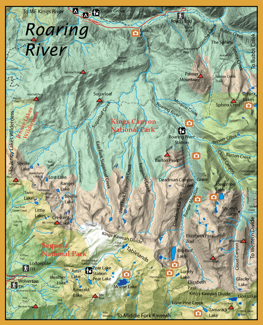
Directions:  There are two trailheads to get into the Roaring River Basin, Roads End and Wolverton. Roads End is steep with a 5,000 foot climb out of the canyon, 14 miles to the Roaring River Station. Wolverton can be a longer hike-in from Elizabeth Pass, 24 miles with a steep 4,300' climb up to the pass or you can take an off-trail entrance from the Pear Lake Ranger Station going through Tablelands, an 18 mile distance with a less steep 4,000' grade. The Roads End is at the end of Hwy 180 where it ends within a loop just past Cedar Grove Village within Kings Canyon National Park. From Fresno, take Hwy 180 east into Grant Grove and follow the South Fork of the Kings River east. Roads End is 85 miles from Fresno.
|
|
Notes:
Roads End trailhead (5,000' elevation)
consists of a ranger station and a place to park. There is a hiking trail on both sides of the river with a footbridge at Roads End and another at Bubbs Creek. Either footbridge will get you to the south side of the Kings River. It's about 2.5 miles from Roads End to Bubbs Creek.Along the Bubbs Creek trail, a series of switchbacks will cover a 2500' elevation gain within one mile and you will reach a junction connecting the Sphinx Creek Trail headed south. The Sphinx Trail covers another 2500' elevation gain until you reach Avalanche Pass at 10,013 feet., 8.3 miles from the trailhead. Once over the pass the trail takes you down 2700' into the Roaring River Canyon, the Ranger Station being 14 miles from the trailhead.
Roaring River (at the Ranger Station): This is a four mile section of the river with a trail following the river up to a confluence with Brewer Creek. Contains Browns and Rainbows 7-12". Golden-Hybrids usually start above the confluence with Brewer Creek.
Deadman Canyon Creek: Deadman Canyon Creek used to be known as Copper Canyon for a copper mine at the head of it's canyon. A Basque sheepherder was buried just above Ranger Meadow in 1887 by the name of Alfred Moniere and the canyon was referred to "Deadman Canyon" ever since..Mostly Brookies, 7-9 inches
Josephine Lake: Go 4.5 miles up Cloud Canyon from the Roaring River Ranger Station. The area is called Cement Table Meadow. At this point you need to hike off-trail over Glacier Ridge to Josephine Lake. Josephine Lake is about 1.5 miles from Cement Table Meadow. Contain Rainbows, 9-12"
Big Bird Lake: Take the Elizabeth Pass trail up Deadman Canyon to the upper portion of Ranger Meadow, about 5.4 miles from the Roaring River Station. Staying left of the outlet stream of Big Bird Lake, work your way off-trail up to the lake, another mile. Big Bird Lake is about 6.5 miles from the Roaring River Station. Contains small Brookies 7-9".
The Wolverton Trailhead will take you to the following lakes:
Heather Lake: (9275' elevation) 3.5 miles from the trailhead. Contains Brookies, 7-9 inches.
Emerald Lake: (9225' elevation) 4.3 miles from the trailhead, follow the outlet stream a tenth mile up to the lake. Contains Brookies 7-9 inches.
Aster Lake: (9110' elevation) 4.3 miles from the trailhead, follow the Emerald Lake outlet stream down 2 tenths mile to the lake. Contains Brookies 7-9 inches.
Pear Lake: (9550' elevation) 6 miles from the trailhead. Contains Brookies 7-9 inches.
Moose Lake: (10,545' elevation) About 9 miles from the trailhead, going 2.5 miles off trail from Pear Lake Ranger Station. Fishless.
Lonely Lake: (10,785' elevation) About 14 miles from the trailhead, going off-trail from Pear Lake Ranger Station across Tablelands and crossing Pterodactyle Pass. Fishless.
Tamarack Lake: (9215' elevation) About 14 miles from the trailhead using the High Sierra Trail to Bear Paw Meadow, take the Elizabeth Pass trail from Bear Paw and follow the spur trail up Lone Pine Creek 1.5 miles to the lake. Contains Brookies.
The Lodgepole Campground Trailhead can give you access to a number of lakes taking the JO Pass trail to the East Fork Clover Creek trail:
Twin Lakes: (9,400' elevation). About 7 miles from the Lodgepole CG Trailhead. The two lakes have had a good population of Brookies for over 80 years, up to 12".
Ranger Lake: (9,193' elevation), 10 miles from the trailhead. This lake was supported by aerial drops of fingerlings up to 1986. Spawning was unsuccessful due to the outlet creek going dry. Fishless.
Beville Lake: (9,142' elevation). This is just a quarter mile from Ranger Lake to the southeast. Beville may be fishless but may just have very low densities of fish.
Lost Lake: (9,197' elevation), Even though Lost Lake is just 3/4 miles northwest of Ranger Lake, the trail loops around a ridge covering 2 miles to reach the lake. Lost is 12 miles from the trailhead. Lost contains Brookies, up to 12".
Seville Lake: (8,408' elevation)13.5 miles from the trailhead. Contains Brookies, up to 12".
|
| Fishing Regulations (Effective March 1st, 2021)
Kings River, South Fork from its confluence with Copper Creek downstream to the Highway 180 crossing at Boyden Cave.:
Open all year. No restrictions. 2 trout. 4 in possession.
Roaring River inside Kings Canyon National Park:
From the last Saturday in April through November 15, five trout daily bag limit, 10 trout in possession; and, from November 16 through the Friday preceding the last Saturday in April, 0 trout bag limit, artificial lures with barbless hooks only and trout must be released unharmed and not removed from the water. Special Park Regulations below 9000' elevation: 0 Rainbow and 5 trout limit on non-native trout using articifical lures with barbless hooks.
Other Rivers and Streams:
From the last Saturday in April through November 15, five trout daily bag limit, 10 trout in possession; and, from November 16 through the Friday preceding the last Saturday in April, 0 trout bag limit, artificial lures with barbless hooks only and trout must be released unharmed and not removed from the water.
Other Lakes within this area:
Open all year. No restrictions. 5 trout per day. 10 trout in possession.
|