|
Directions: 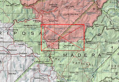 From the town of Merced on Hwy 99, drive 45 miles northeast on Highway 140 to the town of Briceburg. Continuing north the river parallels the highway into Yosemite National Park. Wawona is located on the Wawona Road (the continuation of Highway 41 inside the park), 27 miles (45 minutes) from Yosemite Valley. Wawona is accessible by car year-round, though chains may be required from October through April. A gas station is open year-round in Wawona. From Oakhurst, it is a 20 mile drive on Hwy 41 going north. Wawona is about 5 miles from the South Entrance. |
|
Notes: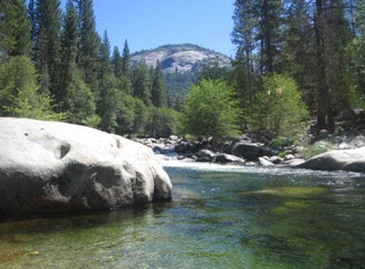
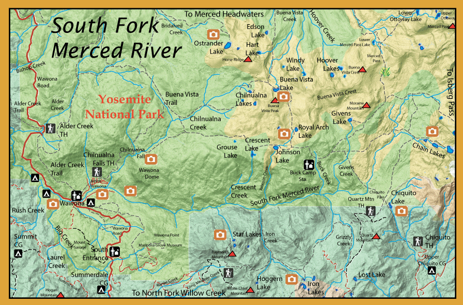
The South Fork of the Merced is mainly accessed from the small community of Wawona within the southern boundary of Yosemite National Park. There are four campgrounds along the South Fork of the Merced near Wawona
which flows through this area. Due to the high number of visitors, the fishing opportunities near these campgrounds are slight. Crossing the river and fishing
along the opposite bank of the campgrounds will give you some possibilities. The fish within these waters are rainbows less than 12”. As you proceed upstream
from the campgrounds, the rainbows get more plentiful and, within the headwater areas, you will find Brookies. Downstream from the campgrounds, the river
enters a canyon and a fishermans trail will take you about a mile downstream from the campgrounds. To get further access to this canyon stretch is to take
the Alder Creek Trail to north to Bishop Creek. The trail will follow the South Fork to the confluence of the Main Merced, a distance of 20 miles, but some of
this trail is unmaintained and requires a few crossings. Near the Bishop Creek confluence rainbows will outnumber Browns 4:1 but the Brown population increases
as you proceed downstream.
Big Creek has rainbows 10-12 inches near the confluence with the South Fork Merced. As you go above the confluence with Laurel Creek, Big Creek will start to
have a brown trout population, some in the 12-16 inch range.
Alder Creek contains both browns and rainbows within it’s lower stretches. Brookies will be caught, sometimes, within it’s upper reaches.
The feeder streams offer trout fishing that might be better than the South Fork. Crescent Creek has brookies, Givens Creek has rainbows, and Johnson Creek
has brookies and rainbows. You can reach these feeder streams from the Chilnaulna Falls trailhead. Chilnaulna Creek above the falls contains small rainbows
8-10 inches but with some larger ones 10-13 inches within the deeper pools. More brookies will populate the water as you get closer to Upper Chilnaulna Lake.
There are three Chilnaulna lakes: Lower Chilnaulna Lake ( 5 acres) at 8375‘ ele is fishless, Middle Chilnaulna Lake (5 acres) has Brookies 10-11 inches, and Upper
Chilnaulna Lake (2 acres) at 8585’ ele also has brookies up to 11 inches. The trail goes directly to Lower and Upper Chilnaulna but you need to take a short off-
trail hike to Middle Chilnaulna Lake. Further on the Buena Vista trail is Buena Vista Lake (12acres) at 9077‘ ele. containing brookies 10-11 inches. Within the Buena
Vista Creek are both brookies and rainbows 8-10 inches. The westernmost Hoover Lake (12acres) at 8696’ ele. is known for large Brookies up to 14 inches. It can
be reached by going off-trail from Buena Vista Creek.
The Buck Creek trail spurs off the Chilnaulna trail about 6 miles from the trailhead. This trail takes you to the Buck Camp Ranger Station and you will pass
Grouse Lake and the larger Crescent Lake, both of these lakes are fishless. The next lake on the trail is Johnson Lake (11 acres) at 8317’ ele. containing
rainbows 10-12 inches. Johnson Creek, above the lake, will also have rainbows in the 10-14 inch range. Royal Arch Lake (12 acres) at 8685’ ele. is a small deep
lake with brookies, 8-12 inches.
Past the Buck Camp Ranger Station going northeast off-trail is Givens Lake (7 acres) at 8825’ ele has some brook trout that approach 15 inches, numbers are low.
About a mile east of the ranger station a trail splits off to the east and will get you to some fine fishing lakes known as the Chain Lakes. A more direct route is to
take either of two trailheads south of the park, either Quartz Mt. or Chiquito trailheads. There are three lakes:
Lower Chain Lake (5 acres) at 8947’ ele. contains rainbows up to 14 inches, Middle Chain Lake (17 acres) at 9092’ ele. has rainbows averaging 11 inches and some
brookies, Upper Chain Lake (32 acres) at 9291’ ele. has only brookies 8-10 inches. The creek below Lower Chain Lake has small rainbows and brookies but the
creek between Lower and Middle Chain Lake will have some nice rainbows in the 8-11 inch range. Breeze Lake above Upper Chain Lake is fishless.
|
| Fishing Regulations (Effective March 1st, 2021)
South Fork Merced River:
From the last Saturday in April through November 15, five trout daily bag limit, 10 trout in possession; and, from November 16 through the Friday preceding the last Saturday in April, 0 trout bag limit, artificial lures with barbless hooks only and trout must be released unharmed and not removed from the water.
Other Rivers and Streams:
From the last Saturday in April through November 15, five trout daily bag limit, 10 trout in possession; and, from November 16 through the Friday preceding the last Saturday in April, 0 trout bag limit, artificial lures with barbless hooks only and trout must be released unharmed and not removed from the water.
Lakes within this area:
Open all year. No restrictions. 5 trout per day. 10 trout in possession.
|