|
Notes: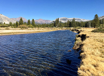
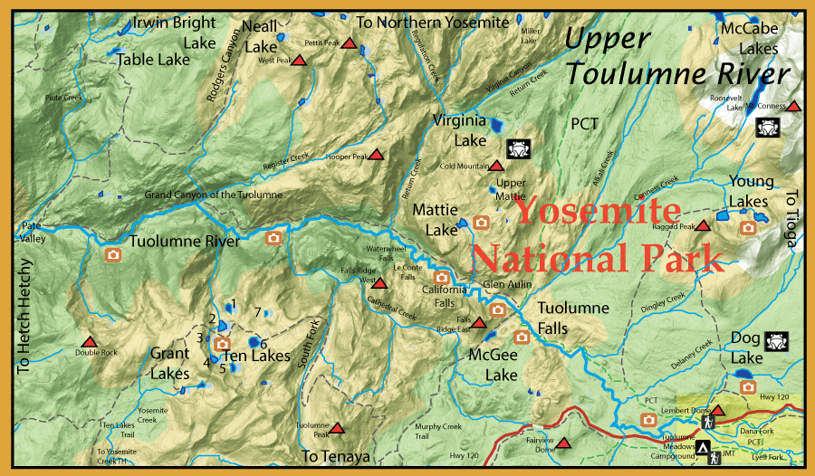
The Upper Tuolumne was historically devoid of trout due to Glacial activity. Native rainbows existed within the lower Toulumne but could not reach the upper sections due to waterfalls and steep inclines. For the past 100 years, the area has been stocked with Rainbows, Brookies, Browns, and Goldens. This stocking has been discontinued since 1991 and the resulting populations are self-sustaining wild trout. Although many of the high elevation lakes have become devoid of trout once again, many areas of the Upper Tuolumne river basin support a good number of trout. Most of these trout are in the 8-10 inch class although there are a number of sites with fish up to 15". The park service has taken an active roll in removing fish from some of the lakes within this area for amphibian restoration. Most notably Lower McCabe Lake, Roosevelt Lake, Upper Mattie Lake, Virginia Lake, and Dog Lake have been either gill-netted or electro-shocked.
Above Hetch Hetchy Reservoir, the Tuolumne is within the Grand Canyon of the Tuolumne for 25 miles. This area extends up to Waterwheel Falls. It contains rainbows, browns, and brookies. Some consider this stretch to be the best fishing with Yosemite Park. Your most direct route to this area is by trail from White Wolf campground, a 7 mile distance, or from Tuolumne Meadows using the Pacific Crest Trail to Glen Aulin, 7.5 mile distance. From Pate Valley, a spur trail will take you to:
Table Lake: At 7046' elevation, 6 miles from Pate Valley. This lake was stocked since the early 1900's with rainbows. Since the end of stocking in 1991, this lake has returned to being fishless.
Irwin Bright Lake: At 7,082' elevation. Named for Irwin Bright, son of Robert Bright (USGS). Irwin planted the first 37 Rainbow trout into this lake in the early 1900's. Contains Rainbows.
Neall Lake: Named after Lt. John M. Neall, 4th Calvary, who helped distribute fish throughout the park when stationed at Yosemite National Park in 1896. Up Rodgers Canyon, 9 miles from Pate Valley with a 5,000 foot gain in elevation. Neall lies within a terminal moraine at 9175' elevation. Contains Rainbows.
The river runs about 5 miles through Tuolumne Meadows offering mainly brookies and browns. It is fairly shallow with deep undercut banks. The water is very clear so stealth is a priority. Dry Flies are your best bet within this section, using terrestrials such as Ants and Hoppers, along the banks.Just north of Glen Aulin is Mattie Lake at 9,222' elevation. Mattie had a reputation for some large Brookies. It still has brookies but most are in the 12" range. Upper Mattie is fishless. On the Murphy Creek trail just south of Glen Aulin is McGee Lake at 8107' elevation. This lake has been recently gillnetted and is now fishless. Taking the PCT north out of Glen Aulin you can reach Lower McCabe Lake at 9820'. This lake has also been recently gill-netted and is intended to be fishless. Upper McCabe still has fish and contains rainbows 14-16" and an occasional Brown trout. It can be accessed by going off-trail along outlet stream of McCabe creek but most visit this lake by way of Saddlebag Lake Trailhead. North of Upper Mattie Lake is Virginia Lake at 9235' elevation. This is a very difficult lake to access and the brookies had a reputation to reaching 18" within this lake. However, this lake is now fishless due to gill-netting for frog restoration. Virginia and McCabe Lakes flow into Return Creek which empties into the Tuolumne. Return Creek has lots of rainbows 8-10 inches throughout its course.
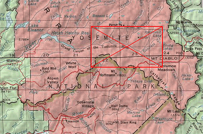
The Tuolumne splits into two forks above the meadows. (Click the map above at Tuolumne Meadows for a more detailed map) The Lyell Fork follows the Pacific Crest Trail (also the John Muir Trail) for ten miles to it's headwaters. The Lyell Fork has mainly brookies, browns, and some rainbows, with the brookies mostly in the upper reaches. Attractor drys such as Yellow Humpies and Royal Wulffs work well. A combination of a dry fly such as a Parachute Adams with a dropper such as a Zebra Midge or Pheasant Tail Nymph is excellent. It is a gentle, clear stretch of water running through meadowland. Most of the stream is 2-6 feet deep with some 20 foot deep pools.While most of the fish are 8-11 inches, there are some 12-14 inch browns that inhabit the undercut banks. Beyond the meadow section, the stream has freestone sections through numerous granite boulders forming pocket water. Stealth is critical in your presentation as the fish tend to be quite spooky. There are two places to park your car for access to the Lyell Fork. You can park at the bridge at Toulumne Meadows and follow the John Muir trail. You will need to hike about a mile upstream as the river section is usually crowded with swimmers from the campground. The other access point is at the Wilderness Permit Center about a mile past the bridge. A trail will take you to a footbridge across the Dana Fork and onto another footbridge on the Lyell Fork. The prime fishing is upstream from this point.
The Dana Fork is a pocket and riffle freestone stream. It also contains browns, brookies, and rainbows, with the rainbows being more prevalent within the faster portions of the stream. Dana Fork has less water than the Lyell Fork but more fish. The fish tend to be smaller in the 6-8 inch class. It is also an excellent stretch for dry flies. Like the Lyell Fork, the fish tend to be quite spooky and you need to use stealth in your presentation. Some areas are tight with obstructions such as Lodgepole Pines and you need to use bow-and-arrow casts to present the flies to the proper areas. The granite stream bottom can be slick so rubber-soled wading boots are recommended.
The area contain numerous fishing opportunities besides the river itself. Yosemite Creek can be reached from Tioga Road at the Yosemite Creek Trailhead. This stream contains mostly Rainbows with an occasional brown or brookie. Goldens were planted here in the 1930's, so some of the rainbows may have the characteristic parr marks of a Golden.
Hiking on the Ten Lakes trail you can reach:
Grant Lakes: About 6 miles from the trailhead. Only Lower Grant (8 acres) at 7257' elevation has rainbows, up to 13-14". Upper Grant used to hold rainbows but is now fishless due to poor spawning habitat.
Ten Lakes: Only seven named lakes are of size. Brookies and Rainbows have been planted within all of these lakes since 1908. The three westernmost lakes, 2, 3, and 4, continue to have rainbows and brookies due to good spawning habitat. The rest of the lakes are fishless. Lake 2 tends to have the larger fish with most in the 10 inch range but an occasional 12-15 inch.
From Tuolumne Meadows you can hike north of the meadows on a trail to:
Young Lakes: Series of three lakes tucked behind Ragged Peak. The lowest lake is at 9883' elevation and the highest lake is at 10,218' elevation. Each lake contains brookies in the 6-10 inch range. Middle Young Lake seems to have the better fishing with brookies averaging 9 inches.
Roosevelt Lake: This lake at 10,184' elevation can be reached by going about 3 miles off-trail following Conness Creek from Middle Young Lake. The creek contains both brookies and rainbows. Roosevelt Lake used to have a number of rainbows reaching 1 lb but these fish have been gill-netted and removed for frog habitat. Considered fishless.
|
| Fishing Regulations (Effective March 1st, 2021)
Upper Tuolumne River:
From the last Saturday in April through November 15, five trout daily bag limit, 10 trout in possession; and, from November 16 through the Friday preceding the last Saturday in April, 0 trout bag limit, artificial lures with barbless hooks only and trout must be released unharmed and not removed from the water.
Other Rivers and Streams within Yosemite National Park:
From the last Saturday in April through November 15, five trout daily bag limit, 10 trout in possession; and, from November 16 through the Friday preceding the last Saturday in April, 0 trout bag limit, artificial lures with barbless hooks only and trout must be released unharmed and not removed from the water.
Lakes within Yosemite National Park:
Open all year. No restrictions. 5 trout per day. 10 trout in possession.
|