Notes: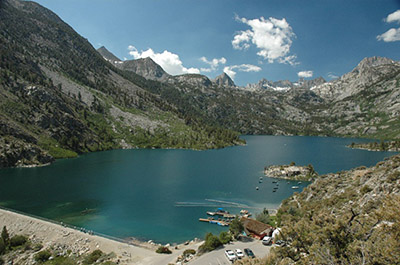
Sabrina Lake Backcountry has it’s own bowl of lakes with exclusive access. You can reach further into the John Muir Wilderness by going through Piute Pass from North Lake or Bishop Pass from South Lake (Click map above on South Lake for details). Sabrina Lake is 200 acres in size at 9,130 feet elevation. It was created by an earthen dam built in 1908. It’s also a very popular destination with a marina and the small community of Aspendell is nearby with some provisions available. It is heavily stocked with 30,000 10-12 inch Rainbows each season. The lake record for Rainbow is 15 Lbs. 12 oz. The lake also contains Brookies . Sabrina Lake is deep, so most flyfishing options are along the southern shore near the inlets. Along Hwy 168, is Intake 2 which can be float tubed and can hold some fairly large Rainbows and Browns. Bishop Creek, below Sabrina Lake, is also heavily used by roadside fishermen. It is heavily planted with Rainbows but also consists of Brookies and Browns. Your best flyfishing opportunities, however, are within the backcountry. The season is last Saturday of April to October 31st. Often, the lake is froze over until late May so that only ice-fishing is available until the thaw.
The trailhead starts at 9,100 feet elevation just below the lake and proceeds along it’s eastern shoreline for about a mile , the trail forks to the left taking you up a ridge toward the Tyee Lakes where you can take the trail further down to South Lake Road for an exit. Along the trail is:
Little George Lake: About 2.3 miles from the trailhead at 10,160 feet. Consists of small Brookies.
George Lake: 2.7 miles from the trailhead at 10,700 feet. Consists of Brookies.
Tyee Lakes: Going over an 11,500 foot ridge you drop into Tyee Lakes, about 4.25 miles from the trailhead at 11,000 feet. There are 6 lakes within this group stretching for about a mile. Lakes #1,4, and 5 contain brookies and rainbows. Lake #2 contains just Brookies and Lake #6 contains just Rainbows. Lake #3 is managed as “fishless”. Lake #1 is at the lowest elevation is 10,300 feet. The nearest exit is 1.5 miles further downstream where the trail meets South Lake Road at the Tyee Lakes trailhead.
Continuing straight on the Blue Lake trail you can access a number of lakes:
Blue Lake: Blue Lake (30 acres) is at 10,400′ and consist of Rainbows and Brookies. It’s a two hour hike in from Lake Sabrina about 3 miles from the trailhead. The lake has lies within a granite cirque surrounded by conifers with the Thompson Ridge as a backdrop to the southeast. The trail goes across the lake’s outlet stream and follows along the lake’s western shore to a granite outcrop, with magnificent views of the lake and surrounding peaks. The best campsites are on located on the granite benches around the west and south sides of the lake.
Donkey Lake: About 3.5 miles from the trailhead at 10,640 feet. Consists of Brookies.
Baboon Lakes: Three lakes of 13, 7, and 3 acres at 11,000 feet elevation. Consists of Rainbows and Brookies. About a 3 hour hike at 3.7 miles from the trailhead.
Sunset Lake: (30 acres) at 11,200 feet elevation. Consists of Brookies. About a 4 hour hike at 5 miles from the trailhead. Must follow creek from Baboon Lakes.
From the western shoreline of Blue Lake the trail forks to the west about 2.5 miles from the trailhead. This takes you to past the Emerald Lakes to a number of other ones:
Emerald Lakes: At 10,400 feet, 3 miles from the trailhead, Emerald consists of 4 small, shallow lakes with Brookies and Kamploop Rainbows. Most of the fish are less than 8 inches.
Dingleberry Lake: About 4.6 miles from the trailhead at 10,500 feet elevation. Consists of Brookies 6-8 inches. Best at the inlet on the southern shore. Good campsites can be found at the north and south end of the lake.
Pee Wee Lake: At 4 miles , the trail forks to the east to Pee Wee and Topsy Turvey Lake Pee Wee is a small lake about 4.4 miles from the trailhead at 10,675 feet. Contains Brookies.
Topsy Turvey Lake: Shallow lake filled with gigantic boulders, about 4.5 miles from trailhead at 10,800 feet. Consists of Rainbows and Brookies.
Sailor Lake: At 4.2 miles from the trailhead the trail forks to the east to Sailor Lake,Moonlight Lake, and Hungry Packer. Sailor Lake is at 11,040 feet about 4.8 miles from the trailhead. Consists of Brookies and Kamloop Rainbows.
Moonlight Lake: Go along the south shore of Sailor Lake and follow the creek up to Moonlight Lake at 11,060 feet. About 20 acres in size with numerous boulders throughout. Consists of Brookies. From Moonlight Lake, you can follow the creek up to Echo Lake about 1 mile further at 11,600 feet. Supposedly, there are Rainbows in the 16 inch class up there.
Hungry Packer Lake: 30 acre lake at 11,070 feet about 5.2 miles from the trailhead. Hungry Packer is deeper than most of the area lakes and contains some large rainbows and brookies. Steep sides along the southern shoreline.
Midnight Lake: Following the trail straight ahead , the trail ends at Midnight Lake at the bottom of a cistern granitic bowl, surrounded on three sides by steep rocky cliffs and jagged peaks. It’s at 11,000 feet elevation about 4.9 miles from trailhead. Talus slopes cascade down to the lakes southern shore. To the west, Mount Darwin (13,831-ft.) pierces the sky. Consists of Brookies.
To the west of Midnight Lake is:
Blue Heaven Lake: At 11,821 feet. Must go off-trail to the west from the inlet of Midnight Lake about 3/4 miles with a 850 foot gain. Contains Brookies.
Hell Diver Lakes: At 11,700 feet. Three small lakes to the northeast of Blue Heaven Lake. Contains Brookies.
Accessed from Dingleberry Lake, you can reach:
Fishgut Lakes: At 11,000 feet. Must go off-trail to the northwest from the inlet of Dingleberry Lake about 3/4 miles with a 550 foot gain. Contains Brookies.
Bottleneck Lake: At 11,122 feet. About 1/4 mile southwest of Fishgut Lakes. Contains Brookies.
Schober Lakes: At 11,700 feet. About 1/2 mile west of Bottleneck Lake. Contains Brookies in the Lower Lake. Brookies and Goldens in the Upper Lake.
Prior to reaching Sabrina Lake is a turnoff to North Lake. There are two trails out of North Lake. One takes you up to Piute Pass into the Humphreys Basin area, the other trail forks to the south and brings you into the Lamarack Lakes area. From the Lamarck Lakes Trail you can encounter:
Grass Lake: A small lake at 9,800 feet elevation with Brookies about 1 mile from the trailhead at North Lake.
Lower Lamarck Lake: About 1.5 miles from the trailhead at 10,600 feet. Consists of Brookies and Rainbows.
Upper Lamarck Lake: Trail ends at 2.0 miles from trailhead. Lake is at 10,900 feet and consists of Brookies and Rainbows.
Wonder Lakes: At Lower Lamarck Lake, go along the northern shore and follow the creek up to Wonder Lakes. The first lake will be about 2.0 miles from the trailhead. There are about a dozen lakes over a two mile stretch starting at 10,800 feet and going up to 11,600 feet, consisting of small brookies.
|
| Fishing RegulationsSabrina Lake and South Lake: Last Saturday in Apr. through Nov. 15. No restrictions. 5 trout per day. All Lakes and Reservoirs in Inyo and Mono Counties (except Bridgeport Reservoir and tributaries; Convict Lake; Crowley Lake; George Lake; Grant Lake; Gull Lake; Horseshoe Lake; June Lake; Lundy Lake; Mamie Lake; Mary Lake; Rock Creek Lake; Sabrina Lake; Silver Lake; South Lake; Twin Lakes (Mammoth); Twin Lakes, Lower and Upper (Bridgeport); Virginia Lake, Lower and Upper): Open all year. 5 trout. 10 in possession. No gear restrictions. All creeks and tributaries: From the last Saturday in April through November 15, five trout daily bag limit, 10 trout in possession; and, from November 16 through the Friday preceding the last Saturday in April, 0 trout bag limit, artificial lures with barbless hooks only and trout must be released unharmed and not removed from the water. |