Notes: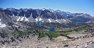
Kearsarge Pass is one of best trails to access the Sierra from the East side. The trailhead is at 9,200 feet and the crest is only a 4.8 mile hike to 11,823 feet, a 2500 foot gain. It is also one of the most popular access trails demanding wilderness permits, sometimes months in advance. The pass was named after the USS Kearsarge ship that sank the CSS Alabama during the Civil War. The nearby hills, Alabama Hills, at the trailhead was named after the confederate ship and the locals that had more Union sentiments decided that “Kearsarge” was an appropriate response.
The trail starts at the west end of the trailhead parking area. It begins with a series of switchbacks through sage and manzanita. At 0.3 miles is the spur trail going to Golden Trout Lakes.
Golden Trout Lakes: About 1.5 to 2 miles from trailhead with a 2100 feet gain. There are 4 lakes within the system, the trail branches off at 1.35 miles to two of the lakes to the north, #1 and #2. Sometimes, these two lakes are referred to as Dragon Peak Lakes or Upper Golden Trout Lakes. The first lake is #1 (11,264′ elevation) which is the only lake known to hold some Golden Trout. About 1/4 mile further, 2 miles from the trailhead, is Golden Trout Lake #2, the largest of the four lakes. This lake holds Brookies. Taking the trail fork to the southwest are Golden Trout Lakes #3 and #4 (11,374′ elevation). Both of these lakes are known to hold Brookies. However, recent reports are that no fish are evident in Golden Trout Lake #3.
At 0.8 miles, you enter the John Muir Wilderness. The trail climbs along the northside of the slope above Independence Creek and proceeds upon some switchbacks to the basin holding Little Pothole Lake. Pothole is a geologic term describing the erosion of a granitic basin by glacial melting.
Little Pothole Lake: Elevation at 10,045. 1.5 miles from the trailhead. Contains Brookies.
The trail switchbacks up a rocky slope above Little Pothole Lake, at the top of the switchbacks the trail traverses a boulder field and arrives at Gilbert Lake.
Gilbert Lake: About 2.25 miles from trailhead with a 1200 feet gain. Lake is 5 acres at an elevation of 10,450 feet and flows into Independence Creek.Consists of Brookies and some Browns.
At 2.5 miles the trail reaches the east end of Flower Lake. There is a side trail that heads to Matlock and Bench Lakes.
Matlock Lake: Covering 8 acres at 10,547 feet. About 1/2 miles from Flower Lake. Fishless.
Bench Lake: Covering 5 acres at 10,881 feet. About 3/4 miles from Flower Lake. Fishless.
Flower Lake: Covering 4 acres at 10,531 feet. About 2.5 miles from trailhead and consists of Brookies, 8-9 inches, and some Browns. Good campsites on the north and east end of the lake.
From Flower Lake, the trail heads north through some scattered pines before turing westward again. The trail climbs along the base of a talus slope to the north of the trail. At 3.5 miles, the trail arrives at an overlook above Heart Lake.
Heart Lake: A 6.5 acre lake at 10,850 feet consisting of Rainbows and Brookies.
The trail climbs a number of switchbacks up a headwall to the basin below Kearsarge Pass. At the bottom of this basin is Big Pothole Lake.
Big Pothole Lake: 7.5 acres lake at 11,341 feet consisting of Brookies. 4.2 miles from trailhead and must go off-trail the last 1/4 mile.
The trail ascends on long swithbacks within the talus slope of the north basin. The final long switchback brings you to the top of Kearsarge Pass (elevation, 11,823′) and the boundary to Kings Canyon National Park, 4.8 miles from the trailhead.
The trail descends into the backcountry of Kings Canyon National Park connecting with the John Muir Trail/Pacific Crest Trail. The trail forks just below the pass with the lower fork going along the shores of Bull Frog Lake (Not shown on the map) just 3/4 miles below the pass. The upper fork maintains elevation and intersects with the JMT/PCT. However, the lower fork will also intersect with the JMT/PCT, just at a lower elevation. The tributary stream feeding Bull Frog Lake provides access to Kearsarge Lakes.
Bullfrog Lake: 8 acre lake at 10,660 feet. Consists of small Brookies. About 5.5 miles from Trailhead.
Kearsarge Lakes: Three lakes with the larger two about 6 acres each. Consists of Brookies in the 9″ class. Follow the creek from Bullfrog Lake, the largest lake is about 1 mile upstream from Bullfrog at 10,900 feet.
The lower fork will intersect with JMT/PCT, Taking the JMT/PCT northward for .25 miles the trail forks with a side trail going to Charlotte Lake (not shown on map) and Gardiner Pass.
Charlotte Lake: 9 acre lake at 10,400 feet, about 6 miles from trailhead. Consists of Rainbows and Brookies. Rainbows were planted in the 1950’s and have a sustained population with sizes up to 12″. A ranger station is on site with camping areas.
|
| Fishing RegulationsLakes within John Muir Wilderness on Kearsarge Pass: Open all Year. No restrictions. 5 trout per day. 10 trout in possession. Kearsarge Lakes and all other lakes within Kings Canyon National Park: Open all Year. No restrictions. 5 trout per day. 10 trout in possession. Inyo County, Southwestern portion, in all waters bounded by the Inyo County line on the south and west, Independence Creek on the north (open to fishing), and Highway 395 on the east. From the last Saturday in April through November 15, 5 trout daily bag limit, 10 trout in possession; and, from November 16 through the Friday preceding the last Saturday in April, 0 trout bag limit, artificial lures with barbless hooks only and trout must be released unharmed and not removed from the water. All creeks and tributaries: From the last Saturday in April through November 15, 5 trout daily bag limit, 10 trout in possession; and, from November 16 through the Friday preceding the last Saturday in April, 0 trout bag limit, artificial lures with barbless hooks only and trout must be released unharmed and not removed from the water. |

