|
Notes: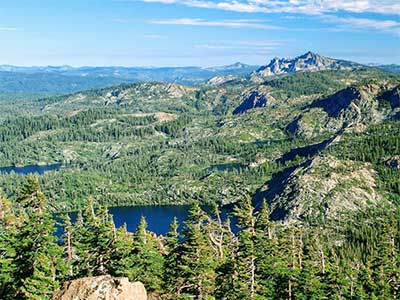
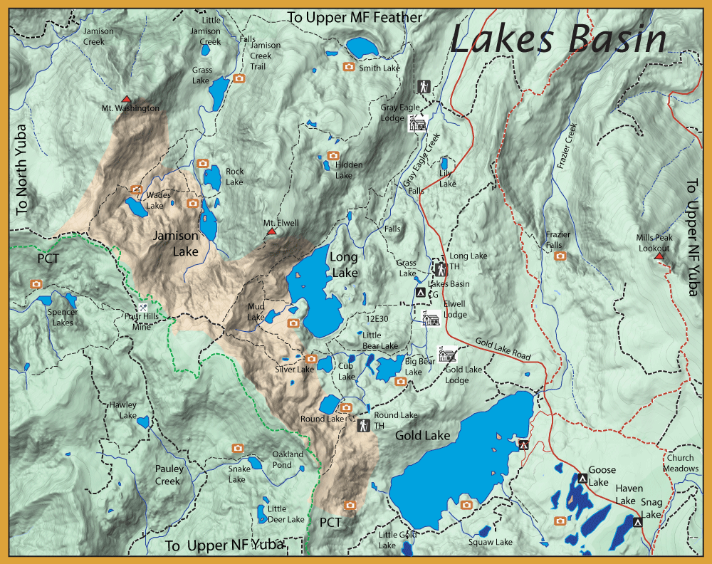
The Lakes Basin has a nickname of the "Lost Sierra". Basically due to the fact that it has over 50 glacially derived lakes, 8500 foot peaks, and vastly fewer visitors than that of Yosemite, Lake Tahoe, or Mammoth. No camping is allowed within the basin so there remains a sense of remoteness. This region was also the summer hunting grounds of a prehistoric tribe known as the Martis. Their petroglyphs can be see near the Lakes Basin Campground dating back 10,000 years. There are three historic lodges in the area that go back over 100 years. Elwell Lodge was built in 1920 by William Drew and the lodge is still being run by his decendents with ten cabins having kitchens and tent cabins. The Gold Lake Resort was first built in 1919 and also continues today with nine cabins and three tent cabins, the resort providing meals within their dining building. The Gray Eagle Lodge was started in 1924 and has over 20 cabins as well with an excellent restaurant, "Firewoods". Gold Lake is the largest lake within the basin and got it's name during the 1849 Gold Rush when a novice prospector named, Thomas Stoddard, found gold nuggets along the shore but had to make a hasty retreat from the area due to hostile natives. He found refuge in Downieville requiring medical attention and food, the locals provided all that he required upon his showing them the nuggets he found at "Gold Lake". The next Spring, Stoddard led a group of miners to the area but they found no gold and the infuriated miners threatened to hang him. Later, Stoddard found gold in a dry wash near Grass Valley and became very wealthy, retiring in Sonora. He died Sept 6th, 1887 at the age of 67 and is bured in the Sonora cemetary. The Lakes Basin was devoid of trout prior to the 1860's and some of the lakes still require stocking as adequate spawning is limited. The shallow lakes are also subject to winterkill from ice. Aerial stocking was discontinued in many of the lakes after 2000 as there is a push to establish wild trout populations. However, many of the surviving populations are Brook trout that remain stunted in size due to limited food sources.
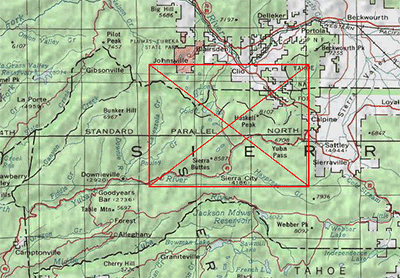
Lakes Basin Recreation Area:
Gold Lake (ele: 6,407 feet) is the largest natural lake (510 acres) in the Plumas
National Forest and resides in Lakes Basin. Flyfishing is best around the shallows of the shoreline. The lake holds Browns
and Rainbows, as well as Brookies and Mackinaw Trout. It was known for some trophy-sized Browns but very few are caught currently. Even the Rainbows and Brookies have diminshed leaving Gold Lake primarily a Mackinaw Trout lake. The natural feed in Gold Lake is Crayfish and
red-sided minnows. Mohair Leech and Bugger patterns work well stripped on a sinking line. When the fish
are feeding on the surface, try Griffith's Gnat, Parachute Adams, and ant patterns. Winds can be quite strong at Gold Lake in the afternoon, so you must use caution with float tubes and small boats.
Below Gold Lake are three
smaller lakes: Goose, Snag, and Haven Lakes.
Goose Lake used to have plenty of rainbows and brookies. It was an easily accessible fishery close to the road and popular with anglers. In 2000, CDFW found MYL frogs at the lake and ceased all plantings of the trout. The trout cannot reproduce here and soon became extinct.
Snag Lake (20 acres, 6,600 feet elevation) at one time was an excellent fishery but has become barren due to over fishing and the cessation of trout stocking by CDFW due to the presence of MYL frogs found in 2001. The lake is named for the numerous stumps and snags that exist within it's waters. The last trout planting was 2017 and is now being managed as "wild" trout.
Haven Lake (elevation 6,673 feet) used to consist of small
brookies until CDFW found two MYL frogs at the lake in 2001. CDFW immediately ceased any further planting and the lake is now fishless.
Taking a jeep road around the southern shore of Gold Lake you can reach:
Squaw Lake was another lake with plentiful Brook trout prior to 2001. CDFW chose to stop any further aerial planting of rainbows and brookies and today it is fishless.
Little Gold Lake: This used to be an excellent brookie fishery but stocking was halted in 2001 and it is now fishless.
From the Lakes Basin campground, a nearby trail (12E30) goes directly to Long Lake in 3/4 mile.
Long Lake (141 acres, 6,531 feet elevation) is the second largest lake within the Lakes Basin region containing self-sustaining Kamloop Rainbows, 11-13 inches, and some self-sustaining Brookies. Currently being managed as a wild tout fishery. It is ideal for float tubing. The lake has some depth with a maximum 190 feet. Woolly Buggers on a sinking
line is your best bet.
Taking the trail around the southern shore of Long Lake you can reach the Round Lake Loop trail, a 3.75 mile trail from Gold Lake Lodge, which takes you to:
Big Bear Lake: 6,474 feet elevation. Maximum depth is 15 feet. Last stocked in 2018 with Rainbows. Has a small population of Brookies.
Little Bear Lake and Cub Lake: Used to have both rainbows and brookies but fish stocking ceased in 2000. There have been no fish surveys since 2000 and reports are that the lakes are fishless at this time.
Silver Lake and Round Lake: These lakes used to have rainbows but they have been eliminated due to poor habitat and no stocking since 2000. The lakes continue to have a Brookie population, however. Silver was planted with Goldens at one time but these fish are gone as well..
Continuing on the Mud Lake Trail out of Silver Lake, you hike west of Long Lake.
Mud Lake: Contains Rainbows and Brookies. Being managed as a wild trout fishery.
Jamison Lake Area:
Within the upper Jamison Creek watershed are four lakes, Jamison Lake, Rock Lake, Wades Lake, and Grass Lake. These lakes can be accessed from either the Smith Lake Trailhead at Gray Eagle Lodge or the trailhead from the Plumas Eureka State Park. At the Plumas Eureka State Park, the trailhead starts at the campground near the Jamison Mine site. You follow Little Jamison Creek but the trail is called Jamison Creek Trail. In one mile you come to a waterfall on the Little Jamison Creek and proceed another 1/4 mile to Grass Lake. If you set out from Gray Eagle, add another 2.5 miles to the route.
Grass Lake (elevation 5,860) is very shallow and the fish tend to stay in the middle of the lake, requiring a float tube. Grass Lake has both rainbows and brookies in the 9-10 inch class.
Proceeding another mile is a fork in the trail. The Jamison Creek Trail continues to the left and the Rock Lake trail forks to the right. You can reach Rock Lake in a mile from the fork.
Rock Lake (elevation 6,310 feet) is a beautiful lake with stunning scenery. The lake contains small brookies in the 8-9 inch class which the angler only has success in the early morning or late afternoon since the brookies head for the deeper water during the day.
Jamison Lake (elevation 6,275 feet) is only a quarter mile south of Rock Lake. A small stone dam only 5 feet tall was constructed to enlarge the water storage of the lake. This is also a Brookie lake with Brookies in the 8-9 inch class. The two inlets at the southern end of the lake tend to have a large number of fish due to the fallen structure and tree stumps.
Taking the left fork at the Rock Lake intersection, Wades Lake can be reached in about 3/4 mile.
Wades Lake (6,549 feet elevation) is about three miles from the trailhead. The lake has a good midge hatch that makes for good fishing when the wind is down. If the wind is up, try fishing the eastern shore since the food tends to get blown in that direction and will stack up the fish. The lake contains both Rainbows and Brookies in the 9-10 inch class. Last stocking of Brookies was 2018.
The Smith Lake trail, out of Gray Eagle, connects with the Jamison Lake trail adding 2.5 miles to the route. However, this trail will reach Smith Lake (6,079 feet elevation) which is one of most beautiful lakes within the Lakes Basin. Smith Lake contains brookies and rainbows.
The Pacific Crest Trail goes along the western crest of Lakes Basin. From this section of the PCT you can reach the following lakes:
Snake Lake: Very popular with the 4x4 groups. With Brookies
Little Deer Lake: Hatchery Rainbows
Hawley Lake: Last stocked in 2013 with Rainbows
Spencer Lakes: Last stocked in 2018 with Rainbows..
The 4x4 groups also have access to these lakes using rough 4WD trails out of Gold Lake.
|