Little Lakes Valley – discover many lakes in a day

 | |||
Suggested Flies for Little Lakes Valley area: | |||
Other Local Favorites: Stillwater Flies: | Dry Flies: | Nymph Flies: Wet Flies: | |
Directions: Little Lakes Valley is about 15 miles north of Bishop on Hwy 395. Turn on Rock Creek Road at Tom’s Place. The lake is about 9 miles from Hwy 395. Go past the lake on the westward side and proceed for two more miles to the Mosquito Flats Trailhead. | ||
Notes:
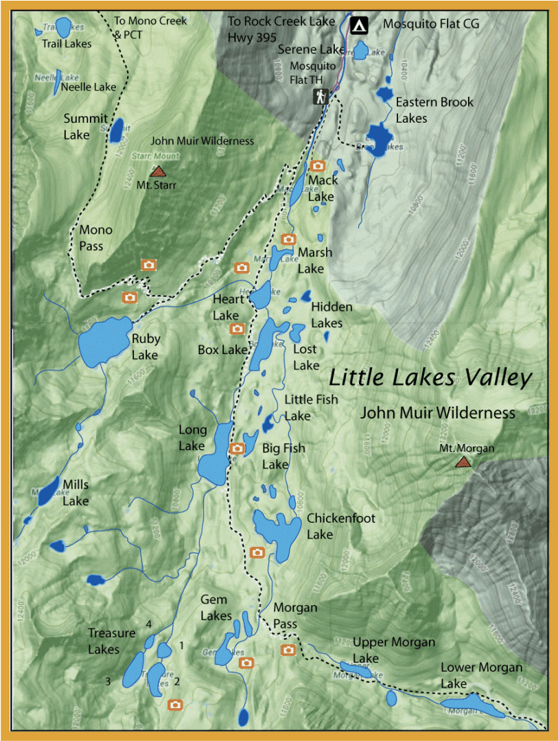
Little Lakes Valley can be accessed from behind Rock Creek Lake at a trailhead, Mosquito Flats . At 10,230 feet elevation, Mosquito Flats is one of the highest places within the Sierra that you can park. The parking area is very crowded during the Summer so that parking may be restricted. Your best bet is to arrive in the early morning or midweek. Little Lakes Valley is a classic glacial cirque with a rim of high, jagged peaks. As the glaciers retreated, it left lateral moraines from which a number of lakes formed. This area has at least two dozen lakes within a day’s walk and climbs of less than 400′. Ice-out in Little Lakes Valley is in late May or early June. Due to high snow accumulation on the surrounding peaks and the low elevation gradient, the valley remains very wet until mid-August and is a haven for mosquitos. Summer thunderstorms are also a common occurrence. The main trail used to be the service road for the Pine Creek Tungsten mine and was abandoned in the late 1950’s. The trail forks off to the right going to Mono Pass and PCT. The left fork goes over Morgan Pass to the defunct mine. The area offers the chance to get a Sierra Grand Slam in one day. The streams throughout the area hold numerous brookies 7-10 inches.
Lakes within the ValleyEastern Brook Lakes: 10 acre and 3 acre Eastern Brook Lakes (ele 10,350) is 0.5 miles from the trailhead on a separate trail. The lake used to have Brookies and Rainbows, however, the 2008 DFG backcountry guide indicates that these lakes are now fishless. Mack Lake: Starting at 10,300′, a 0.5 mile walk will bring you to 4 acre Mack Lake (ele 10,470) with mostly Brookies and some Browns in the 7-11 inch class. The inlet has a dense growth of reeds so most fish the southern shoreline or the outlet where there is deeper water. The trail runs along the northern shoreline with sheer cliffs to the lake. Marsh Lake: 6 acre Marsh Lake (ele 10,480) is about 1 miles from the trailhead. It contains Brookies and Browns in the 7-10 inch class. Heart Lake and Box Lake: About 1 mile from the trailhead is Heart Lake (ele 10,500) and 13 acre Box Lake (ele 10,600) with Brookies, Rainbows, and Browns in the 7-10 inch class. As with all the lakes, the inlets and outlets are the best locations. Heart has two inlets, one from Ruby Lake, the other from Box Lake. The trail gets close to Heart’s Box Lake inlet and thus there are usually a lot of hikers that stop within that area. A better location to fish is to cross Rock Creek below Heart’s outlet and fish the southern shoreline. Hidden Lakes: There are five Hidden Lakes (ele 10,750) south of Heart Lake. Hidden Lake #3 is the largest and the only one with fish, Rainbows and Brookies. There is no trail so you need to walk cross country to reach them. Lost Lake: Just east of Box Lake with Rainbows, Browns, and Brookies. There is no trail so you need to walk cross country to reach them. Long Lake: About 2 miles from the trailhead is 25 acre Long Lake (ele 10,550) with Rainbows, Browns, and Brookies. Little Fish and Big Fish Lake: Consists of Rainbows with Brookies in the inlet stream. Chickenfoot Lake: Up ahead at 2.75 miles, you have 22 acre Chickenfoot Lake (ele 10,750) with Brookies, some Rainbows and Browns.
Morgan PassGoing over Morgan Pass you have Upper and Lower Morgan Lakes (8 and 16 acres, respectively) with Rainbows and Brookies. Near Morgan Pass at 3.75 miles is are three Gem Lakes (ele 11,000) with Rainbows and the four Treasure Lakes (3,7,1,7 acres) at 11,200′ with Goldens in the northern two lakes (#3&4) and Brookies in the southern two lakes (#1&2). Considered to be self-sustaining populations by DFG.
Mono PassTaking the right fork near the trailhead to Mono Pass you encounter the following lakes: Ruby Lake: At an elevation of 11,150 feet. This 35 acre lake is 1.5 miles from the trailhead with an 800′ vertical climb. The trail branches off to the right of the main trail at Mack Lake. The lake has a rocky shoreline with better access along the northern shoreline. There are three inlets, one from nearby Mills Lake, and one outlet. Ruby holds Brookies in the 7-10 inch class. Mills Lake: This lake is at an elevation of 11,600 feet. It is 6 acres in size and is about 2.25 miles from the trailhead which takes about 2 hours since you must climb 1300 vertical feet.. Mills Lake contains Goldens in the 8-11 inch class. Access to Mills is best from the trail at Ruby Lake, there is no trail to Mills Lake so you have to proceed cross country over a boulder field. It was last stocked in 1997 and last surveyed in 1996. DFG considers the lake self-sustaining. Mono Pass is about three miles from the trailhead. Over Mono Pass (12,100′) are three lakes: Summit Lake: 1/3 mile past the pass is Summit lake. At an elevation of 11,894 feet, this lake is fishless. Trail Lake: This lake is at an elevation of 11,200 feet. It is is about 1.75 miles from Mono Pass just off the trail. Contains Brookies. Neelle Lake: This lake is at an elevation of 11,385 feet. It is is about 2 miles from Mono Pass going off-trail from Trail Lake. Contains Goldens. | ||
Fishing RegulationsLakes within Little Lake Valley:Open all year, five trout daily bag limit, 10 trout in possession. Rock Creek and all other creeks and tributaries:From the last Saturday in April through November 15, 5 trout daily bag limit, 10 trout in possession; and, from November 16 through the Friday preceding the last Saturday in April, 0 trout bag limit, artificial lures with barbless hooks only and trout must be released unharmed and not removed from the water.
| ||

