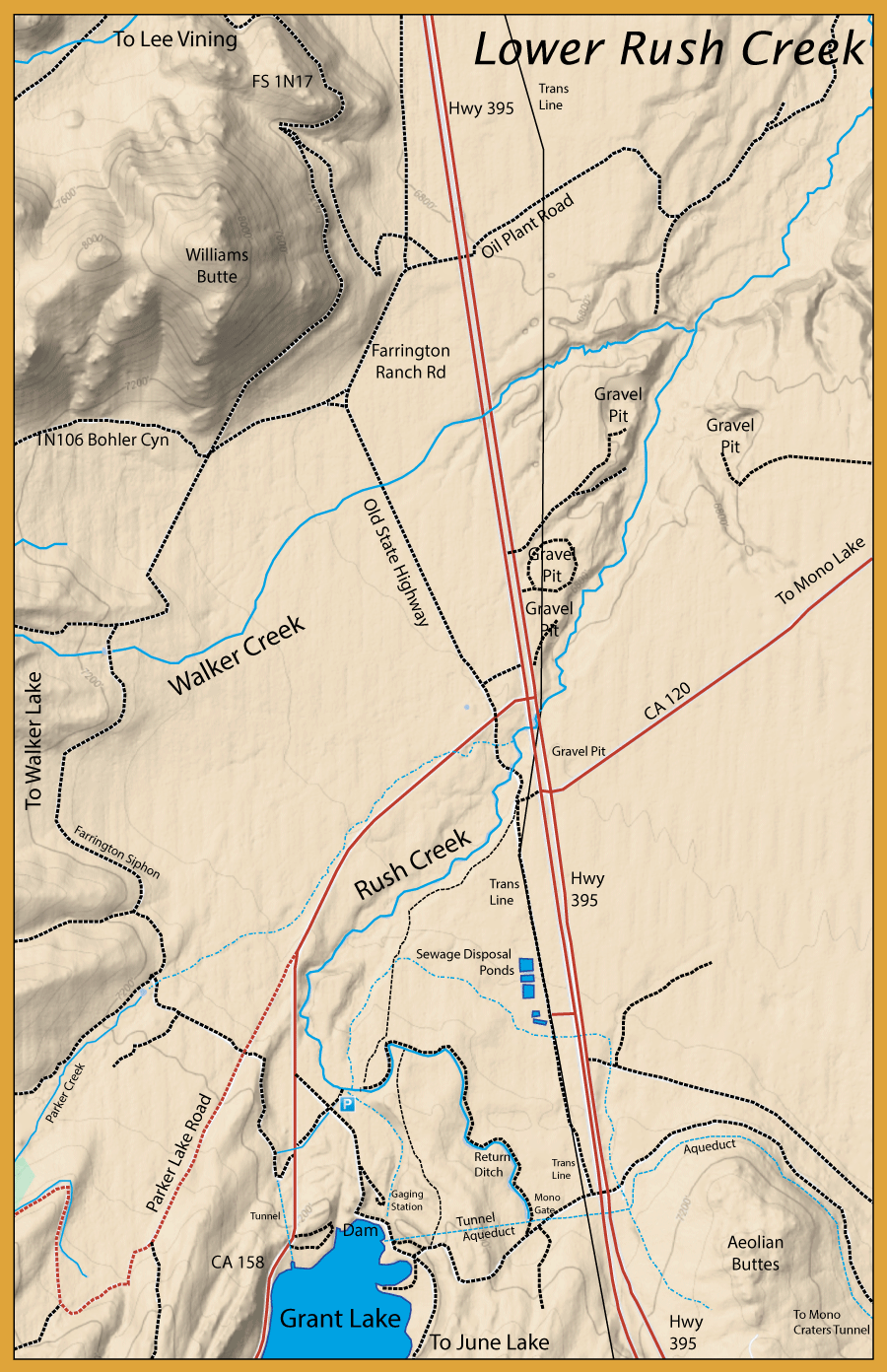
Notes: 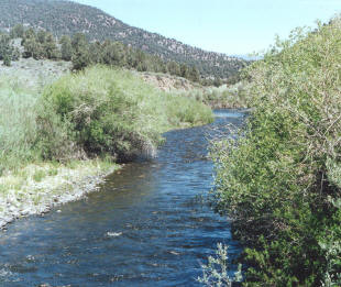 Lower Rush Creek is designated as a Special Regulation Wild Trout stream with a Zero limit catch and release using barbless flies and lures. Season: Last Saturday of April to Nov. 15th. Prior to 1941, Lower Rush Creek was a delta-like stream with deep pools and large undercut banks. Multiple side channels had gravel beds for spawning. Riparian vegetation, including large Cottonwoods, Western Birch, and Jeffrey Pine covered much of the area between Grant Lake and Mono Lake. Brown Trout were introduced to Lower Rush Creek in 1919 and by 1941, this area was considered one of the finest Brown Trout streams within the Sierra with mostly 2 lb Browns and an occasional 5-6 Lb. Brown. After 1941, water from Rush Creek was diverted to the L.A. Aqueduct. This resulted in a lowering of the water table and over a 50% loss in Riparian vegetation. Meadowlands were reduced by 70%. Mono Lake retreated to lower levels. During the early 1980s, heavy rains and snowpack exceeded the ability of the LA Aqueduct to carry all the water from Rush Creek and flows were allowed to drain back into Mono Lake. Trout from upstream repopulated Lower Rush Creek and a fishery was reestablished. This provided an opportunity to restore Lower Rush Creek through the Fish and Game codes that should have been enforced much earlier. A lawsuit was initiated by Dick Dahlgren and Barrett McInerney on behalf of Mammoth Fly Rodders in 1984 against the Los Angeles Department of Water and Power. By 1994, a decision was reached which would mandate minimum flows and restore the riparian vegetation to what it looked like prior to 1941. Most of Lower Rush Creek above Hwy 395 to Grant Lake has been restored. The City of L.A. hired a stream restoration firm and the river between Grant Lake and Highway 395 was re-created to what it might have looked like before the diversions. Deep pools, undercut banks, riffled stretches, spawning gravels were recreated within a couple of seasons. A healthy trout population developed quickly within this section of the restored creek. Just above Hwy. 395, Rush Creek picked up the flows from Parker creek and Walker Creek about a mile below Hwy 395. Due to the lower levels of Mono Lake, the flows of Lower Rush Creek have created a deep, straight canyon with thin riffles and steep gradients. Cal Trout and Mono Lake Committee now represent the interests of the original lawsuit and restoration activities continue. Lower Rush Creek is designated as a Special Regulation Wild Trout stream with a Zero limit catch and release using barbless flies and lures. Season: Last Saturday of April to Nov. 15th. Prior to 1941, Lower Rush Creek was a delta-like stream with deep pools and large undercut banks. Multiple side channels had gravel beds for spawning. Riparian vegetation, including large Cottonwoods, Western Birch, and Jeffrey Pine covered much of the area between Grant Lake and Mono Lake. Brown Trout were introduced to Lower Rush Creek in 1919 and by 1941, this area was considered one of the finest Brown Trout streams within the Sierra with mostly 2 lb Browns and an occasional 5-6 Lb. Brown. After 1941, water from Rush Creek was diverted to the L.A. Aqueduct. This resulted in a lowering of the water table and over a 50% loss in Riparian vegetation. Meadowlands were reduced by 70%. Mono Lake retreated to lower levels. During the early 1980s, heavy rains and snowpack exceeded the ability of the LA Aqueduct to carry all the water from Rush Creek and flows were allowed to drain back into Mono Lake. Trout from upstream repopulated Lower Rush Creek and a fishery was reestablished. This provided an opportunity to restore Lower Rush Creek through the Fish and Game codes that should have been enforced much earlier. A lawsuit was initiated by Dick Dahlgren and Barrett McInerney on behalf of Mammoth Fly Rodders in 1984 against the Los Angeles Department of Water and Power. By 1994, a decision was reached which would mandate minimum flows and restore the riparian vegetation to what it looked like prior to 1941. Most of Lower Rush Creek above Hwy 395 to Grant Lake has been restored. The City of L.A. hired a stream restoration firm and the river between Grant Lake and Highway 395 was re-created to what it might have looked like before the diversions. Deep pools, undercut banks, riffled stretches, spawning gravels were recreated within a couple of seasons. A healthy trout population developed quickly within this section of the restored creek. Just above Hwy. 395, Rush Creek picked up the flows from Parker creek and Walker Creek about a mile below Hwy 395. Due to the lower levels of Mono Lake, the flows of Lower Rush Creek have created a deep, straight canyon with thin riffles and steep gradients. Cal Trout and Mono Lake Committee now represent the interests of the original lawsuit and restoration activities continue.
There are about 5 miles of fishable water between Grant Lake and Hwy 395. The first segment is about 1.5 miles and is a slow flowing stream through the Return Ditch of Mono Gate #1 to the natural channel. The canal is 2-5′ deep with a 15′ to 25′ width. 90% of the fish are Browns with some Rainbows and Brookies. The Browns can get up to 18″ in length. They are very spooky within this section since there is little cover and the water is clear. You will find the fish laying along the edges demanding upstream casts. Use a long leader with a 6x-7x fluorocarbon tippet. This is excellent dry fly water for sizes #16-22. The next segment is about 1 mile long and is within a relatively steep canyon with alternating cascades and pools. Riparian vegetation including Jeffrey Pine and Cottonwood line this corridor. The next segment covers 3.25 miles, to about one mile below Hwy 395 where it reaches a bedrock formation known as “the Narrows” and the Walker Creek confluence. This area is relatively flat and open. Small Mayfly and midge patterns, such as #20 Zebra Midge, work well here. There are a good population of caddis, so small rock worm and pupa patterns in size #18-20. Hoppers and Black Ants are a good choice during the summer months. “The Narrows” is the fourth segment with vertical walls and cascading plunge pools. From “The Narrows” to Mono Lake is about 4.7 miles and was historically known as the Rush Creek Bottomlands. Pre-1941, this area had sinuous channels that looked much like the Upper Owens. It contained high quality spawning gravels with riffles and runs. This area also had many spring-fed channels that fed the creek and provided cool water temps during the Summer months. The upper part of Bottomlands, just below “The Narrows” is 1.8 miles and consists of mostly runs, riffles, and pools. It has good cover and spawning bottom. The next 1.6 miles has even more runs, followed by pools and riffles. Good spawning water exist here too. The final segment to Mono Lake is about a mile. This has poor trout habitat with lots of sand. Erosion is taking place due to the lowering of Mono Lake.
Excellent short film on Lower Rush Creek by Bothy Studios. The Trout that Saved Mono Lake
In 1941, Rush Creek, a famous brown trout fishery, and major Mono Lake tributary was diverted to supply water to the ever-growing population of Los Angeles. Over the decades that followed, the lack of water had turned Rush Creek into a dry creek bed and was slowly reducing Mono Lake to a dust bowl. In 1984, after a rare two-year snow event in the Sierras filled the dry creek bed, fly fisherman Dick Dahlgren discovered thousands of trout in Rush Creek. A lawsuit, lead by attorney Barrett McInerney, won a monumental battle in 1991 in a court decision that required the Los Angeles Department of Water and Power, under the supervision and guidance of Cal Trout and the California State Water Resources Control Board, to restore the Rush Creek fishery to its original 1941 condition. This true David vs Goliath story about water wars in the west follows Dick Dahlgren as he revisits Rush Creek after 25 years to see the progress that’s been made to restore the fishery. In a shocking discovery he finds that they may have won the battle to restore Mono Lake’s historic water levels, but the trout in Rush Creek that saved Mono Lake are losing the war.
|