This region is best accessed from the Copper Creek Trailhead at Roads End of Kings Canyon National Park. From Fresno, take Hwy 180 east into the Grant Grove unit of Kings Canyon and continue east following the South Fork of the Kings River until it reaches Road’s End. About 85 miles from Fresno.
Notes:
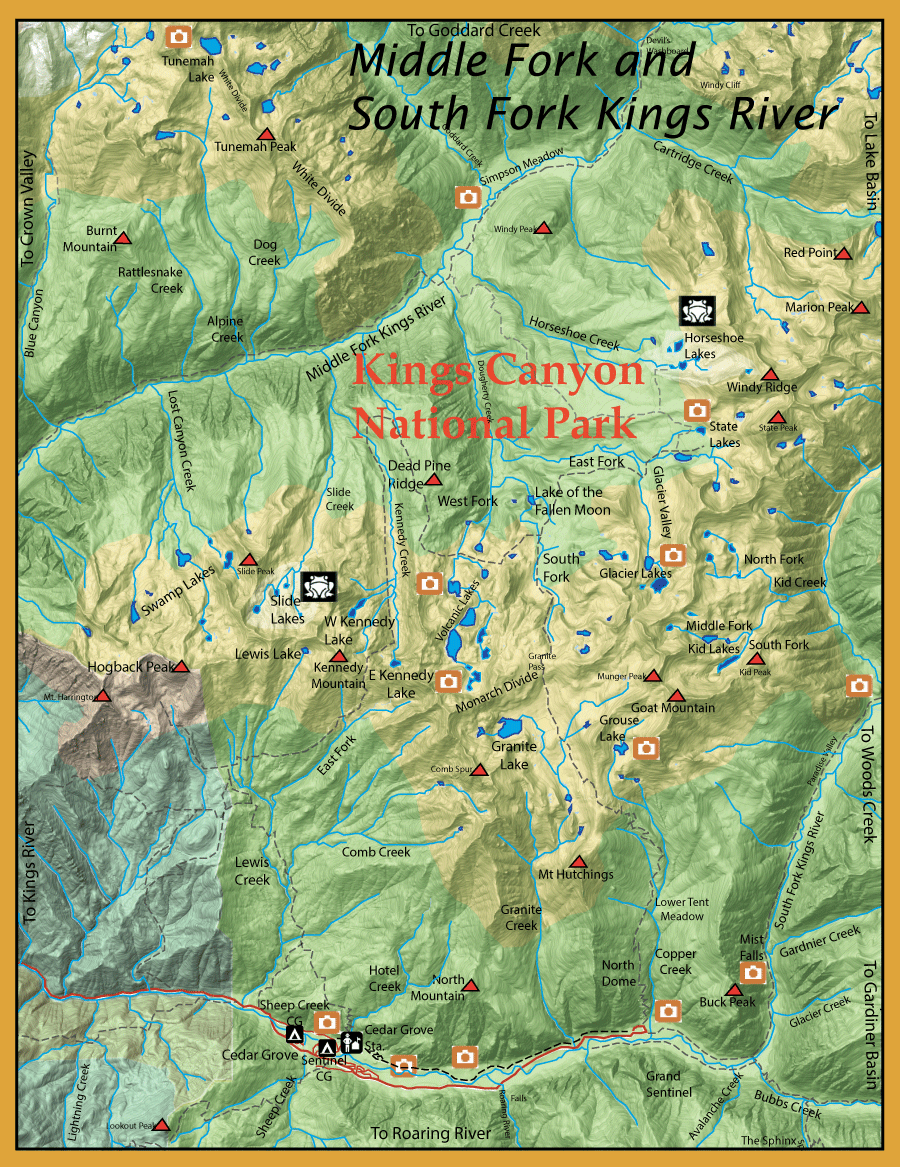
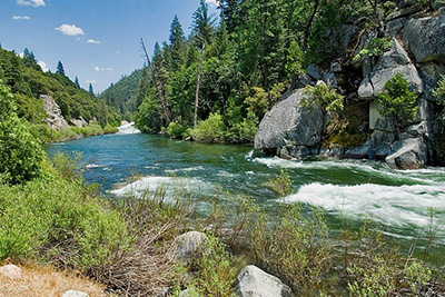
There are over 800 miles of streams and 500 lakes within Kings Canyon National Park. Access is the major problem into the Middle Fork area since it sits in the deepest canyon within the United State at 8,350 feet below Spanish Mountain. TheMiddle Forkconsists ofRainbowsandBrowns, withBrookiesin it’s upper reaches. Taking the Crown Valley trailhead to Tehipite Valley, the trail goes about 1 mile through the fairly level valley and then resumes a steeper ascent for about 2.5 miles up to Blue Canyon, which also has a spectacular waterfall. Lost Canyon is about 5.2 miles upstream from Tehipite Valley. At the Lost Canyon convergence you are at 4,600 feet elevation. Alpine Creek is about 6.5 miles upstream from Tehipite Valley at 5,400 feet elevation. Above Alpine Creek, the MF Kings goes through a broader valley for about 7 miles at Simpson Meadow. The trail goes alongside the river with an exit trail at Horseshoe Creek. The Horseshoe Trail will get you over the 11,000 feet peaks into the SF Kings at Copper Creek, about a 16 mile trek. TheSouth Forkof the Kings from the confluence with Copper Creek downstream to the Hwy 180 crossing at Boyden Cave is open all year with a 2 trout limit. The waters above the confluence of Copper Creek are open the last Saturday of April to Nov. 15th. This is also true for the Middle Fork and all it’s tributaries. Even though the South Fork is technically open year round, the road is usually closed after Nov 8th and does not reopen until snow melt which could be in late March. With an early warm spell, the river can be a rushing torrent and fishing will not be possible until the water levels come down and warm up. Generally, the river is fishable by the end of April. As you approach the Cedar Grove Trailhead, the SF Kings tends to be pocket water with mostly Browns in the 10-12 inch size. Above Cedar Grove, the river becomes much slower but with plenty of trout in the 8-10 inch class. April brings Golden Stoneflies, so try using #10-12 Kaufmann Stoneflies in tan or mottled black and brown. Caddis flies are also present in April as well as March Browns. Try using a CDC Cripple, a #12 reddish-brown Parachute Hares Ear, or a Comparadun. When there are late periods of runoff, the Upper Kings might not be fishable until mid-June. A combination of Golden Stonefly Nymphs and a size #12-14 dropper of a Prince Nymph, Hare’s Ear, or Pheasant Tail will help get the rig down into the deeper reaches of the river. As the river further drops, try attractor dries, such as an Orange Stimulator (#8-10) or a Parachute Adams (#12-16). A spotted caddis hatch occurs in September, use a Kings River Caddis, size 12-14. Try the pocket water and micro-eddies near shore. Concentrate on water that is 3-4 feet deep.
Many feel that the Upper Reaches of the Kings River is one of the best wild trout fisheries on the west slope of the Sierra. What the river may lack in sizable fish, it makes up for in quantities. Survey results from the State of California show that most of the fish within the South Fork Kings are Browns and Rainbows in the 6-8 inch class with a few larger ones up to 14 inches.
From the Trailhead at Cedar Grove you can take a trail up Lewis Creek to the following areas: Lewis Creek: Lewis Creek extends for about 6 miles from the outlet of Lewis Lake at 10,000 feet. It drops down to about 4800 feet where it meets the SF Kings. Consists of Rainbows, Brookies, and Browns. Kennedy Creek:About 10 miles from the trailhead. Kennedy flows northerly from East Kennedy Lake at an elevation of 9600 feet and flows alongside the trail for 3.5 miles down to 8600 feet and continues on to the MF Kings.Consists of Rainbows and Brookies. Swamp Lakes: This is a group of 6 lakes and 8 lakelets within three canyon basins all draining into Lost Canyon Creek. The most northwestern of the lakes is fishless and the lake below it is scheduled for fish removal. The other two lakes might have fish, one is reported to have a few large rainbows. Slide Lakes: Consists of three lakes, a couple of lakelets and four swampy areas. All of the area is fishless. The middle lake is scheduled for fish removal for confirmation. This will be an amphibian restoration region. Kennedy Lakes: Two Lakes, East Kennedy and West Kennedy below Kennedy Pass on the Monarch Divide. East Kennedy is closest to the trail, a quarter mile due east at 10,190′ elevation. This lake is fishless. West Kennedy can be accessed following the West Fork of Kennedy Creek up to the lake at 9,993′ elevation. This lake is also fishless.
From the Trailhead at Copper Creek you can take a trail ot of the canyon with a 5000′ climb over 6 miles to the following areas: Grouse Lake: From the trail at the 6 mile mark, follow the outlet stream 0.6 miles to the lake. Grouse Lake, 10,469′ elevation, used to have Rainbows prior to 1980. They died out due to lack of spawning habitat and the lake was barren from about 20 years. Sometime in the mid-nineties someone planted Brookies within the lake and the Brookies have continued to do well. They average 9-11 inches. Granite Lake: Elevation at 10,450 feet. At the 7 mile mark on the trail, you reach the Granite Lake Basin. Proceeding another mile on the trail you reach the largest lake within this basin, Granite Lake, and must hike a half mile off-trail to reach it. About 9.5 miles from the trailhead. Consists of Brookies. Kid Lakes: Most take the pass below Munger Peak to access this area from the Copper Creek Trail. You must go 2 miles northeast from Grouse Lake off-trail. This route will drop you into the first lake on the South Fork of Kid Creek. The South Fork Kid Lake at 10620′ is fishless. Following the outlet stream down from the South Fork, you reach the confluence of the Middle Fork. The lower two lakes, 10,400′ and 10,500′ elevation, of this middle fork have rainbows up to 11″. 10.5 miles from the trailhead. The North Fork lakes are also fishless.
Crossing the Granite Pass on the Monarch Divide, 10 miles from the Copper Creek Trailhead, you can access the following: Volcanic Lakes: Series of about 10 lakes from 9,400 feet to 10,400 feet in elevation. About 12.5 miles from the trailhead. You need to go over Granite Pass and hike on a spur trail to the northernmost lakes above the West Fork of Dougherty Creek. Working your way upstream, you’ll encounter most of the lakes. Almost all of the lakes consist of Rainbows. Glacier Lakes: Going off-trail for one mile east of the Copper Creek Trail from the MF of Dougherty Creek you can reach the westernmost Glacier Lake. The lower lake ia at 10,149′ and contains Golden and Rainbows up to 11″. The upper lake is fishless. Another group of lakes is another mile to the west at the end of Glacier Valley. The lower Glacier Lake at 10,429′ elevation contains Goldens, 7-9 inches. The upper lake is fishless. State Lakes: Two lakes at 10,300 feet and about 14 miles from the trailhead. Upper State Lake is shallow and fishless. Lower State Lake consists of Goldens and Rainbows. Horseshoe Lakes: 8 lakes about 2 miles north of State Lakes. Three of the lakes are fishless and four of the lakes are scheduled for physical fish removal. Only, the lake are at 10,223 feet elevation next to Horseshoe Meadows consists of Rainbows.
Middle Fork of the Kings River(Simpson Meadow): A trail follows the Middle Fork down to Tehipite Valley. You can exit out on the Crown Valley trail to Wishon Reservoir. Or, you follow the trail upstream up into Le Conte Canyon and exit out at South Lake (on the East Side Sierra). All of the Middle Fork has good fishing for Rainbows in the 8-10″ size class. Closer to Tehipite the rainbows can reach 10-12″.
Fishing Regulations
Middle Fork Kings River inside Kings Canyon National Park:
From the last Saturday in April through November 15, five trout daily bag limit, 10 trout in possession; and, from November 16 through the Friday preceding the last Saturday in April, 0 trout bag limit, artificial lures with barbless hooks only and trout must be released unharmed and not removed from the water. Special Park Regulations below 9000′ elevation: 0 Rainbow and 5 trout limit on non-native trout using articifical lures with barbless hooks.
South Fork Kings River upstream from the confluence with Copper Creek:
From the last Saturday in April through November 15, five trout daily bag limit, 10 trout in possession; and, from November 16 through the Friday preceding the last Saturday in April, 0 trout bag limit, artificial lures with barbless hooks only and trout must be released unharmed and not removed from the water.
South Fork Kings River from its confluence with Copper Creek downstream to the Highway 180 crossing at Boyden Cave.:
Open all year. No restrictions. 2 trout. 4 in possession.
Other Rivers and Streams:
From the last Saturday in April through November 15, five trout daily bag limit, 10 trout in possession; and, from November 16 through the Friday preceding the last Saturday in April, 0 trout bag limit, artificial lures with barbless hooks only and trout must be released unharmed and not removed from the water.
Other Lakes within this area:
Open all year. No restrictions. 5 trout per day. 10 trout in possession.
Used to monitor number of Google Analytics server requests when using Google Tag Manager
1 minute
_gid
ID used to identify users for 24 hours after last activity
24 hours
_gac_
Contains information related to marketing campaigns of the user. These are shared with Google AdWords / Google Ads when the Google Ads and Google Analytics accounts are linked together.
90 days
_gali
Used by Google Analytics to determine which links on a page are being clicked
30 seconds
_ga
ID used to identify users
2 years
__utmx
Used to determine whether a user is included in an A / B or Multivariate test.
18 months
__utmv
Contains custom information set by the web developer via the _setCustomVar method in Google Analytics. This cookie is updated every time new data is sent to the Google Analytics server.
2 years after last activity
__utmz
Contains information about the traffic source or campaign that directed user to the website. The cookie is set when the GA.js javascript is loaded and updated when data is sent to the Google Anaytics server
6 months after last activity
__utmc
Used only with old Urchin versions of Google Analytics and not with GA.js. Was used to distinguish between new sessions and visits at the end of a session.
End of session (browser)
__utmb
Used to distinguish new sessions and visits. This cookie is set when the GA.js javascript library is loaded and there is no existing __utmb cookie. The cookie is updated every time data is sent to the Google Analytics server.
30 minutes after last activity
__utmt
Used to monitor number of Google Analytics server requests
10 minutes
__utma
ID used to identify users and sessions
2 years after last activity
SourceBuster is used by WooCommerce for order attribution based on user source.
Name
Description
Duration
sbjs_migrations
Technical data to help with migrations between different versions of the tracking feature
session
sbjs_current_add
Timestamp, referring URL, and entry page for your visitor’s current visit to your store
session
sbjs_first_add
Timestamp, referring URL, and entry page for your visitor’s first visit to your store (only applicable if the visitor returns before the session expires)
session
sbjs_current
Traffic origin information for the visitor’s current visit to your store
session
sbjs_first
Traffic origin information for the visitor’s first visit to your store (only applicable if the visitor returns before the session expires)
session
sbjs_udata
Information about the visitor’s user agent, such as IP, the browser, and the device type
session
sbjs_session
The number of page views in this session and the current page path