|
Notes: 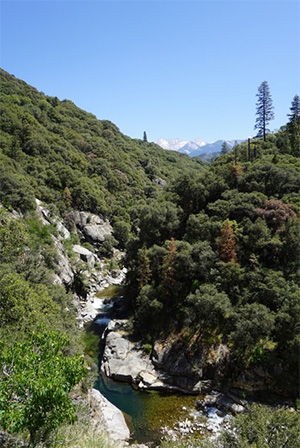
The name, Kaweah, is derived from a local tribe known as the Gawia. Within the Yokuts language, Gawia means crow or raven's cry. Settlers coming into the area during the mid-1800's mispronounced the "G" in Gawia with a "K". The tribe was so named because they were reportedly known to be a loud and rowdy group of people, like a flock of crows. The Kaweah River system contains both Browns and Rainbows. Generally these fish average 10-12" but the size is often dependent upon water flow, particularly during drought years. The Kaweah and it's tributaries are open year-round to angling with a 5 fish daily limit, 10 in possession. All waters within the Sequoia National park are designated Catch & Release only with a 0 limit on Rainbows and 5 fish limit on Browns. This restriction applies to waters below 9000' elevation. Artificial lures and flies with barbless hooks are required. Generally the water is clear which requires stealth and good presentation. The best fishing is within the Park. The Dept of Fish and Game used to plant the lower reaches of the Kaweah river,outside the park, with about 4,000 rainbows each spring and summer. The program was discontinued due to water temperatures getting too warm for a self-sustaining population. The waters below the park boundaries are dominated by bass, crappie, and bluegill.
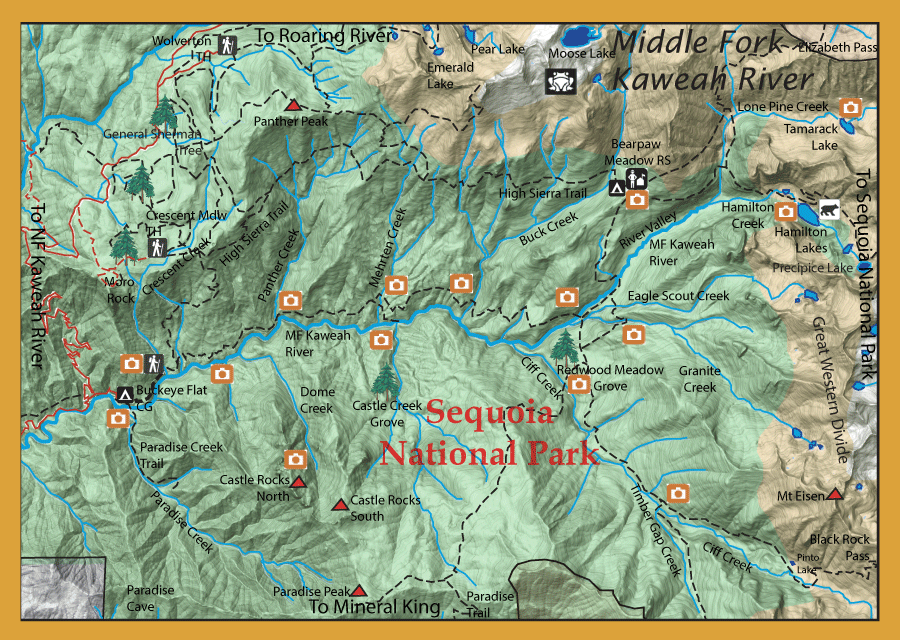
The Middle Fork Kaweah Trail from Buckeye Flat Campground will allow you to follow the Middle Fork at an elevation about 200 to 500' above the river with access to the river at Mehrten Creek and Granite Creek confluences. There is a dirt road on the left prior to reaching Buckeye Flat Campground that will take you to the trailhead. The trailhead has room for nine or so vehicles with bear boxes available. The trail reaches Panther Creek within 3 miles.This area has a number of campsites available. However, there is no access to the river from this trail at Panther Creek as the canyon walls are steep and dangerous. Best access to reach this section of the river is from the footbridge that is just upstream from Buckeye Flat Campground. Buckeye Campground has 28 sites with easy access to the river. Better fishing is away from the campground. The river within this section is a freestone stream with a number of plunge pools up to the confluence of Moro Creek. The streambed is scoured by the heavy runoff during the Spring and early Summer and insect activity is poor. Once the stream levels are low enough to allow access, there are many pools that hold fish, mostly browns, and you will find rainbows within the runs. However, temperatures quickly become too warm by mid-summer and this section is not fishable until early Fall. From Moro Creek to Panther Creek, the MF Kaweah becomes more like a slot canyon with access being quite difficult. The pools and runs are still there but pressed against the smooth sides of the canyon walls. The slot canyon continues past Panther Creek and start to open as you get closer to Mehrten Creek. There is an access trail from the Middle Fork Kaweah Trail to the river just upstream from the Mehrten confluence. The river is much more like a freestone stream within this section. Not as many pools as within the lower section near Buckeye Flat but plenty of boulders and runs. The river tends to get thinner once past Bucks Creek and the gradient steeper as you approach Cliff Creek. Past Cliff Creek, the river transitions back into a slot canyon with numerous small pools until it reaches Granite Creek. At Granite Creek, you have another access to the river from the trail as a bridge goes across the MF Kaweah in this location. Upstream from Granite Creek, the river has another steep gradient as a freestone stream until it reaches River Valley where the stream opens up and has a number of riffle sections and small pools. The trail provides another last access to the river at the base of this valley. The MF Kaweah ends at the confluence of Lone Pine Creek and Hamilton Creek.
Cliff Creek: Contain Rainbows up to 10".
Hamilton Lake: Three lakes, 17 miles from the trailhead. The first lake is the smallest at 8,000' ele., the second is the largest at 8235' ele., and the third is at 9822' ele. The lower two lakes contain 10-12" Rainbows.
Precipice Lake: (10,300' ele.) This lake is fishless.
Tamarack Lake: (9215' ele.) 19 miles from the trailhead. This lake contains Goldens, 7-9".
|
| Fishing Regulations (Effective March 1st, 2021)
Middle Fork Kaweah River:
From the last Saturday in April through November 15, 5 trout daily bag limit, 10 trout in possession; and, from November 16 through the Friday preceding the last Saturday in April, 0 trout bag limit, artificial lures with barbless hooks only and trout must be released unharmed and not removed from the water.
Other Rivers and Streams:
From the last Saturday in April through November 15, 5 trout daily bag limit, 10 trout in possession; and, from November 16 through the Friday preceding the last Saturday in April, 0 trout bag limit, artificial lures with barbless hooks only and trout must be released unharmed and not removed from the water.
Other Lakes within this area:
Open all year. No restrictions. 5 trout per day. 10 trout in possession.
|