 |
|||
|
Suggested Flies for the North Fork American River area: Sierra Tahoe Hatch Selection |
|||
|
Stillwater Flies: |
Nymphs: |
Drys: |
|
|
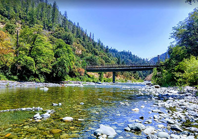
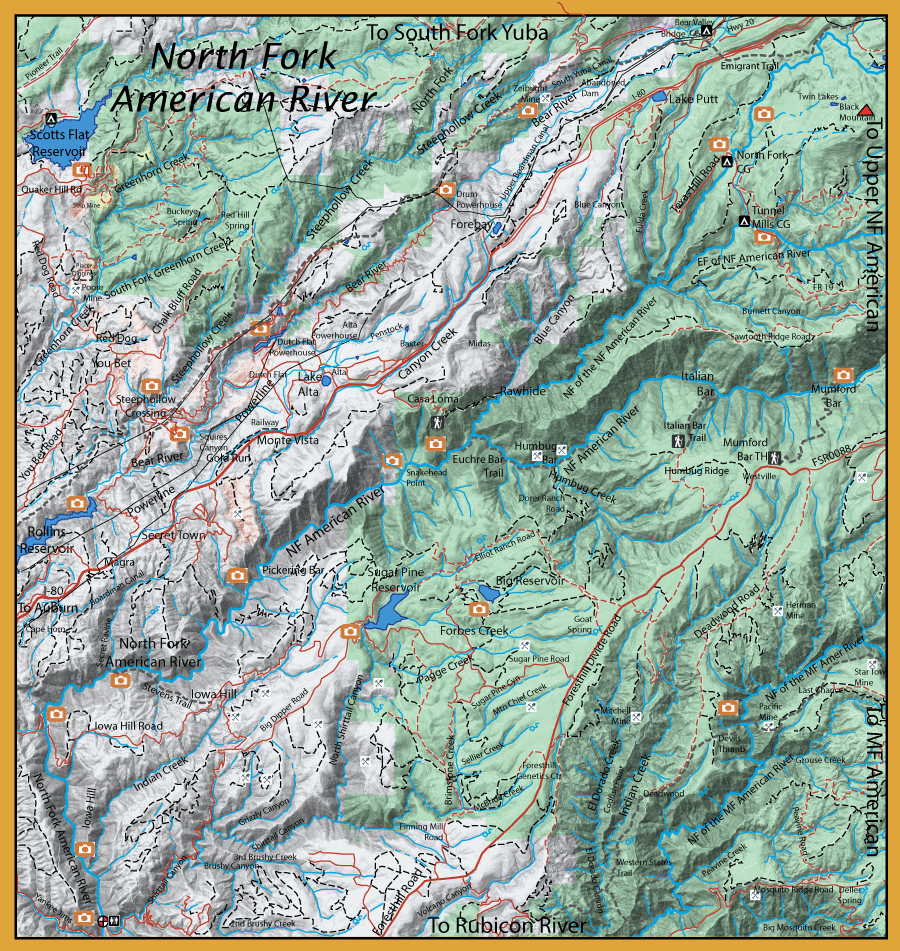
Directions:  From Auburn, on Highway I-80, go Northeast 2 miles to Auburn-Foresthill Road. Turn East and go 18 miles to Foresthill. Continue on Foresthill-Soda Springs Road. Five trails provide access to the North Fork: 1) Green Valley Trail starts 3 miles from the dam at Sugar Pine Reservoir off Elliott Ranch Road. 2) Italian Bar Trail is 12 miles from Foresthill, turn left on Humbug Ridge Road and go 3 miles to Italian Bar trailhead. 3) Mumford Bar Trailhead is 13 miles from Foresthill on Foresthill Road 4) Beacroft Trailhead is 17 miles from Foresthill on Foresthill Road. and 5) Sailor Flat is another 5 miles further on Foresthill Road but the trailhead starts off a high clearance 4 WD road that goes 2 miles to the left. Most of these trails are 3-4 miles to the river and drop about 2000 feet. The American River Trail is along the North Fork and follows the south side of the river from Mumford Bar to Sailor Flat. | |
|
| |
|
Notes: North Fork of the Middle Fork American River: This water consists of small pools, runs, and pocket water. The Rainbows tend to be on the small size of 6-8 inches. The river is within a very deep canyon which tends to cool the ambient temperature. There are good hatches of Mayflies and Golden Stones. Scotts Flat Reservoir: (661 acres at 3,069 feet elev) This lake has both warmwater and coldwater fish with a maximum depth of 80 feet. The lake contains Brown Trout, Rainbow Trout, Kokanee, Large Mouth Bass, Small Mouth Bass, Spotted Bass, Bulhead Catfish and Channel Catfish. The lake is known for a good smallmouth bite particularly in the winter and early spring. Also a good fishery for the browns in the fall as they stage within the creek inlets. Steephollow Creek: This is the largest tributary within the Upper Bear River watershed. Has had a history of goldmining, particularly hydraulic mining with the use of mercury, and is listed within the Clean Water Act as having an impared waterbody with mercury contamination. Contains Browns and Rainbows. Bear River: Bear River is about 74 miles long and flows from 5,000 feet just below Lake Spauding to 35 feet where it meets the Feather River. This river has been greatly impacted by both mining and water projects. This watershed was impacted by hydraulic mining from 1850 to 1884. Sediment was carried downstream and threatened the farmlands of the Central Valley. Creeks and rivers were diverted to bring water to the 30 mine sites on the Bear River. Hydraulic mining was discontinued in 1884 due to lawsuits from the farmers. However, over 2.5 million pounds of mercury was used by these miners and much of this mercury has also settled into the sediment collecting within downstream reservoirs. Microorganisms break down the mercury into methyl mercury which can be consumed by fish and other animals. The highest concentrations have been found below Rollins Lake. This mercury problem will most likely take a few hundred years until the watershed can get back to it's pre-mining state. Rollins Reservoir: (840 acres at 2,170 feet elev) A popular lake with over 300,000 visitors over the Summer months. The reservoir contains Rainbows, Catfish, Bluegill, Largemouth Bass, Smallmouth Bass, Brown Trout, and Carp. The lake is deep, up to 280 feet, providing cooler water temps for the trout to retreat to when the surface water temp reaches 75 degrees in the summer. Best fishing occurs in the Fall, Winter, and Spring. CDFW stocks the lake with about 6,000 rainbows annually 10-12 inches. Smallmouth Bass are probably the most prolific species caught within the reservoir until recently when introduced Spotted Bass have become plentiful and is taking over the bass populations.. Drum Forebay: (20 acres at 4,744 feet elev) Contains Rainbows, Browns, Smallmouth Bass, and Channel Catfish. Cold water is pumped into the forebay from Spaulding Lake. The pond is not stocked but fish seem to get there anyway through the conduit. Lake Putt: Stocked with fish during the early 1900's and the pond continues to have a healthy number of warmwater species. Contains, Smallmouth Bass, Bluegill, and Channel Catfish. Sugar Pine Reservoir: (160 acres at 3,500 feet elev). Created in 1982 and serving the community of Foresthill. It was stocked with Browns up until 1990. Browns still reside here but in few numbers. This is a stocked lake in which CDFW puts in 8,000 to 16,000 pan size Rainbow trout from May through July. Some of these trout become holdovers and reach 14-20 inches the following year. Best fished in the Spring. Contains Rainbows, Browns, and Smallmouth Bass. Big Reservoir, aka Morning Star Lake: (80 acres at 3,620 feet elev): This is a private lake stocked with Rainbows, Largemouth Bass, and Channel Catfish. Cost is about $30/day for fishing and camping is also available.
| |
Fishing Regulations (Effective March 1st, 2021)American River, North Fork, Middle Fork, South Fork and their tributaries above Folsom Lake (Placer, El Dorado, Amador and Alpine cos.): Saturday preceding Memorial Day through September 30th. 5 trout, no gear restrictions. Summer fishing only to protect Spring and Fall Spawning. Bear River from Highway 20 south downstream 2.5 miles to the abandoned concrete dam (the Boardman Diversion Dam).: Saturday preceding Memorial Day through the last day in February. 5 trout, no gear restrictions. Spring angling closure to protect Spawning. Bear River downstream of the abandoned concrete dam (the Boardman Diversion Dam).: Last Saturday in Apr. through Nov. 15. No restrictions. 5 trout per day. 10 trout in possession. All Lakes and Reservoirs: Open all year. No restrictions. 5 trout per day. 10 trout in possession. All other creeks and tributaries: Last Saturday in Apr. through Nov. 15. No restrictions. 5 trout per day. 10 trout in possession.
|