Notes:  Sequoia National Park is in the southern Sierra Nevada east of Visalia, California It was established on September 25, 1890. The park spans 404,064 acres, encompassing a vertical relief of nearly 13,000 feet. The park contains among its natural resources the highest point in the contiguous 48 United States, Mount Whitney, at 14,505 feet above sea level. The park is south of and contiguous with Kings Canyon National Park; the two are administered by the National Park Service together as the Sequoia and Kings Canyon National Parks. Sequoia National Park is in the southern Sierra Nevada east of Visalia, California It was established on September 25, 1890. The park spans 404,064 acres, encompassing a vertical relief of nearly 13,000 feet. The park contains among its natural resources the highest point in the contiguous 48 United States, Mount Whitney, at 14,505 feet above sea level. The park is south of and contiguous with Kings Canyon National Park; the two are administered by the National Park Service together as the Sequoia and Kings Canyon National Parks.
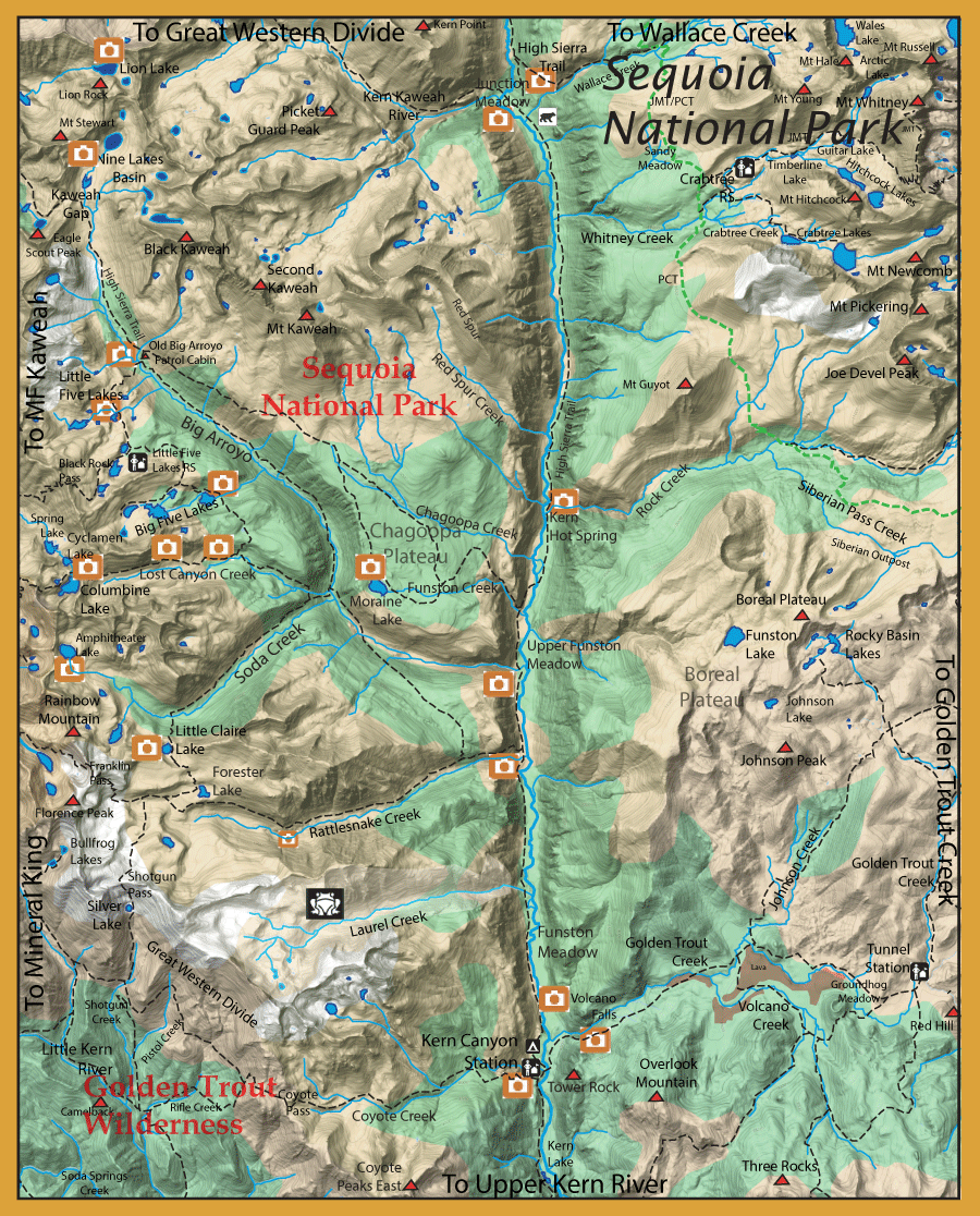
From the trailhead at Crescent Meadow (High Sierra Trail) or the MF Kaweah, you can reach the following areas from the High Sierra Trail (HST) through the Kaweah Gap, a distance of about 17 miles.
Nine Lakes Basin: This is a group of nine lakes within a granite basin. None of the lakes have any trails to them but each is accessible off-trail. The lowest lake (10,460′ ele.), nearest the trail, has rainbows that run about 6 inches with some up to 10″. There is good spawning as to keep the numbers up but a poor food supply. The rest of the lakes are fishless.
Big Arroyo Creek: A mile past Kaweah Gap, the HST trail will follow Big Arroyo Creek for 2 miles down to the junction with Little Five Lakes. There are rainbows on the Big Arroyo within this section of small size. Near the Old Patrol cabin are some small pools holding rainbows somewhat larger, 7-10 inches.
Little Five Lakes Basin: A trail from the Old Patrol cabin heads up to Little Five Lakes. There are more than 5 little lakes within this basin but the “Five” that are named are the three that lie within basin below Black Rock Pass and the two larger lakes north of this basin. Four of the five lakes have the trail close by but Lake 10410 is the northernmost and you have to follow the outlet stream off-trail to reach it. It may have the largest rainbows of the group up to 14″. All of these lakes contain rainbows. Mostly 7-10 inches.
Big Five Lakes Basin: Within the next basin south of the Little Five Lakes Ranger Station lie the Big Five Lakes. The trail splits about 1.5 miles from the Little Five Lakes Ranger Station with the right spur going to the lowest lake at 9830′ ele. and the left spur going to the second lake at 10,260′ elev., the third lake at 10,192′ ele. and the fourth lake at 10,214′. The trail reaches all of these lakes except for the highest lake which is supposed to be fishless. Not much information on the fishing within these lakes but the 5th edition of Sierra South by Winnett indicates that the lower four lakes have Goldens and that the fishing can be “good to excellent”.
Coming over Sawtooth Pass from Mineral King you can reach two excellent lakes for Brookies, Cyclamen and Columbine Lakes.
Columbine Lake: (10,970’ele.) This lake is known for a good population of Brookies, 7-10″. It lies within a granite basin about 560′ below Sawtooth Pass but deep enough to not totally freeze during winter.
Cyclamen Lake: (10,478′ ele.) This lake is just north of Columbine but is 500′ lower than Colmbine over a 1/4 mile distance. The access is a steep descent. This lake is similar to Columbine with another healthy population of Brookies.
The trail heads into Lost Canyon. This canyon creek has a good population of Goldens, 4-6 inches. The best fishing is at the trail junction to Big Five Lakes and the numbers of Goldens thin out as you proceed upstream to timberline. There is a bear box at that junction of the trail. Continuing down the Lost Canyon trail towards Big Arroyo, you meet the trail that heads southwest back to Mineral King via the Franklin Pass. This trail follows Soda Creek for 3.3 miles, often well away from the creek before it leaves the valley, and proceeds up to Little Claire Lake. Ralph Cutter’s book, Sierra Trout Guide, indicated Rainbows within Soda Creek. Do not know the current status.
Little Claire Lake: (10,420′ ele.) Some good campsites at the north end among the foxtail pines. This lake contains Brookies, some up to 11″.
Taking the trail from Little Claire Lake southeast for just past a mile, you reach Forester Lake within the Rattlesnake Creek basin..
Forester Lake: (10,354′ ele). This lake has a heavy population of small brookies, usually less than 7 inches.
Heading down Rattlesnake Creek from Forester Lake. Rattlesnake has a nice population of Kern River Rainbows that are unhydridized remnant populations. Further downstream, the creek picks up speed as it continues through the canyon with narrowing walls. A lower section opens up just prior to a series of waterfalls that flow to the Main Kern River. This section will also have Kern River Rainbows.
Upper Kern River: From Kern Lake to Junction Meadow, the river contains a pure strain of Kern River Rainbows as well as some Brown Trout. Coastal Rainbows and Golden Trout are missing from these waters removing the possibility of hybridization with the Kern River Rainbows. The section between Kern Lake and Upper Funston Meadow is a world-class fishery with Kern River Rainbows up to 20″ or more. Studies conducted within Sequoia National Park indicate that Kern River Rainbows are between 600 to 1400 fish per mile. This would put their population size to about 8,000 to 18,000 fish. For this reason, some fishery experts are concerned that continued competitive pressure from Browns and Brookies might cause this species to become extinct over the next 100 years.
Chagoopa Creek: This stream has a distinct population of Kern River Rainbows that is genetically different from those found with the Kern River. The Chagoopa Falls literally created a barrier that allowed this population to develop distinctly on it’s own.
Kern-Kaweah River: This area also has a distinct population of Kern River Rainbows that is genetically different from those found in the Kern River. A natural barrier exists at Rockslide Lake that keeps any ingress of other populations from the Kern River.
Within the Golden Trout Wilderness, access from Mineral King via Farewell Gap or from Lewis Camp TH.
Little Kern River: This watershed is the ancestral home of the Little Kern Golden. This species developed about 70,000 years ago from Coastal Rainbows that were isolated by natural barriers once glacial waters receeded. Due to introductions of other fish such as Rainbows, Browns, and Brookies, the Little Kern Golden was almost extinct by 1978. A program to eradicate the other competing fish was taken up from 1975 to 1995 and the Little Kern Goldens were re-introduced to their home waters. By 1997, most of the original habitat was deemed fully stocked with Little Kern Goldens. Genetic testing was conducted in 2007 and found that some Rainbow trout contamination continued. The purest strains of Little Kern Goldens are found within the upper tributaries of the LIttle Kern River.
Going over Coyote Pass from the Golden Trout Wilderness, you re-enter Sequoia National Park and follow Coyote Creek to the Kern Canyon Ranger Station.
Coyote Creek: This creek had Little Kern Goldens transplanted from Rifle Creek in the 1880’s.This population continues today. When chemical eradication of the Little Kern Rainbow watershed was implemented in 1975 to 1995, some of the Coyote Creek population was used to reintroduce the Little Kern Golden to these treated waters.
A footbridge near the KC Ranger Station crosses the Upper Kern River and the trail heads up Golden Trout Creek, passing by Volcano Falls.
Golden Trout Creek: Has pure strains of Golden Trout above Volcano Falls. Nearby, Volcano Creek is a tributary where they found the purest strains to reintroduce Goldens into their original habitat. Some 70 Goldens were captured from this tributary during the drought of 2015 and kept at the fish hatchery at American River to preserve the genetic strain. |
| Fishing RegulationsKern River and other rivers and stream within the park: From the last Saturday in April through November 15, 5 trout daily bag limit, 10 trout in possession; and, from November 16 through the Friday preceding the last Saturday in April, 0 trout bag limit, artificial lures with barbless hooks only and trout must be released unharmed and not removed from the water. In waters below 9,000 feet in elevation that are not located in a Developed Area*: - rainbow trout, Sacramento sucker, Kern rainbow, riffle sculpin, and California roach fish must be released
- only barbless artificial flies or lures are authorized
*A Developed Area is defined as an area within one-quarter (1/4) mile of buildings, campgrounds, picnic areas, or parking lots that accommodate more than five (5) vehicles. Other Lakes within this area: Open all year. No restrictions. 5 trout per day. 10 trout in possession. In waters below 9,000 feet in elevation that are not located in a Developed Area*: - rainbow trout, Sacramento sucker, Kern rainbow, riffle sculpin, and California roach fish must be released
- only barbless artificial flies or lures are authorized
*A Developed Area is defined as an area within one-quarter (1/4) mile of buildings, campgrounds, picnic areas, or parking lots that accommodate more than five (5) vehicles. |


 Sequoia National Park is in the southern Sierra Nevada east of Visalia, California It was established on September 25, 1890. The park spans 404,064 acres, encompassing a vertical relief of nearly 13,000 feet. The park contains among its natural resources the highest point in the contiguous 48 United States, Mount Whitney, at 14,505 feet above sea level. The park is south of and contiguous with Kings Canyon National Park; the two are administered by the National Park Service together as the Sequoia and Kings Canyon National Parks.