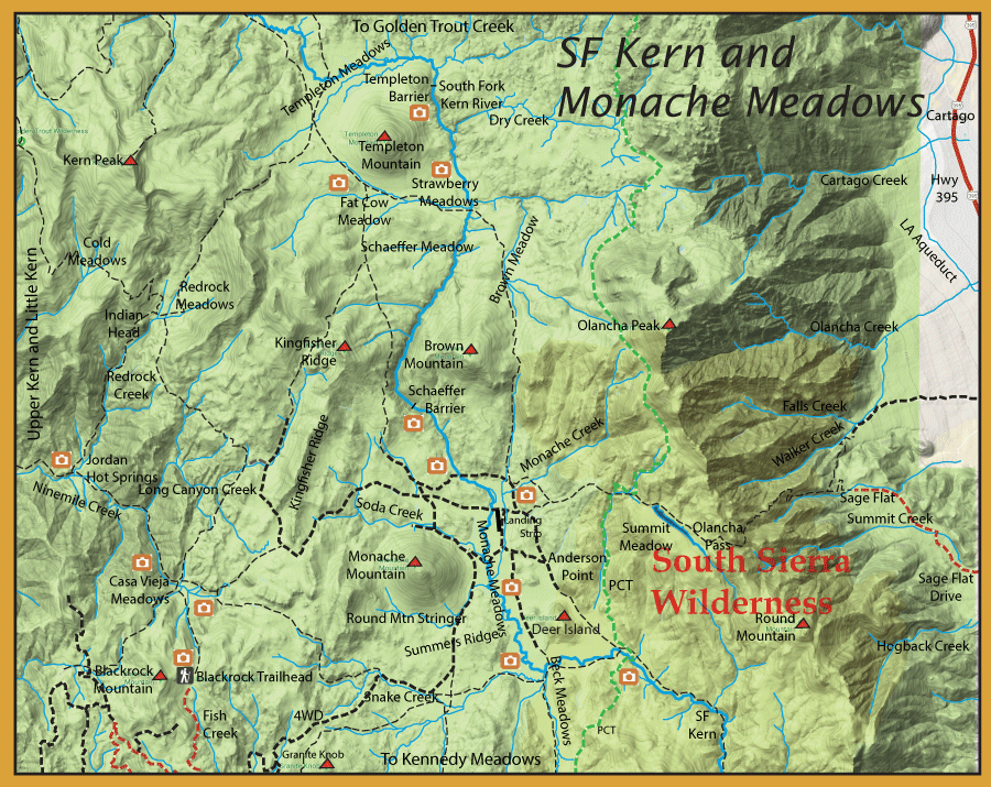
Notes: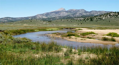 The SF Kern is the ancestral home of our State Fish, the Golden Trout. The Goldens developed over a 70,000 year period on the South Fork of the Kern protected by natural barriers from the intrusions of Coastal Rainbows and their close cousin, the Kern River Rainbow, which resided on the main Kern. The Goldens on the South Fork Kern were able to get all the way up to Golden Trout Creek until a lava flow diverted the creek near Tunnel Meadow towards the Main Kern. Still isolated by natural barriers, the Goldens flourished within both of these watersheds. The South Fork of the Kern has a number of high elevation meadows, ie Monache, Schaeffer, Templeton, Ramshaw. These meadows were an attraction to sheep herders and cowmen for summer grazing. Sheep began to graze within these areas in 1850 and quickly devastated the meadow areas within 10-20 years. Estimates of over 200,000 sheep grazed on the plateau annually. By 1900, sheep were not allowed within the meadows and cows took their place. Cow grazing has been allowed within these meadow sections for over 100 years. In 2001, Whitney and Templeton had grazing suspended and these areas are going under review. Results may influence either suspension of grazing or initiate riparian repair in Monache, Ramshaw, and other meadows of the Kern Plateau. The SF Kern is the ancestral home of our State Fish, the Golden Trout. The Goldens developed over a 70,000 year period on the South Fork of the Kern protected by natural barriers from the intrusions of Coastal Rainbows and their close cousin, the Kern River Rainbow, which resided on the main Kern. The Goldens on the South Fork Kern were able to get all the way up to Golden Trout Creek until a lava flow diverted the creek near Tunnel Meadow towards the Main Kern. Still isolated by natural barriers, the Goldens flourished within both of these watersheds. The South Fork of the Kern has a number of high elevation meadows, ie Monache, Schaeffer, Templeton, Ramshaw. These meadows were an attraction to sheep herders and cowmen for summer grazing. Sheep began to graze within these areas in 1850 and quickly devastated the meadow areas within 10-20 years. Estimates of over 200,000 sheep grazed on the plateau annually. By 1900, sheep were not allowed within the meadows and cows took their place. Cow grazing has been allowed within these meadow sections for over 100 years. In 2001, Whitney and Templeton had grazing suspended and these areas are going under review. Results may influence either suspension of grazing or initiate riparian repair in Monache, Ramshaw, and other meadows of the Kern Plateau.
The intensive activity within the Kern Plateau has transformed the stream habitat of the Golden Trout. There are no longer any pure strains of Goldens within the South Fork Kern river complex. Rainbow trout and Browns were introduced into these areas. The Rainbows hybridized with the Goldens and the Browns competed for a limited food source. In addition, the cows trampled many of the meadow stream embankments, transformed half of the meadows from sod to sage, and have severely damaged many of the fens that supply clean water from headwater springs. Willows were predominate along the SF Kern on the plateau but are now absent from most of the stream embankments, resulting in higher water temps. Stream rehabilitation has been going on within the SF Kern since the 1930’s. Beavers were even introduced to the meadows to assist in riparian restoration. Fish Barriers were constructed at Schaeffer, Templeton, and Ramshaw meadows in the 1970’s and 80’s to keep rainbows and browns from ingressing into Golden trout waters. The waters were even poisoned to reintroduce pure strains of Goldens. The barriers, over time, did not perform well and browns were able to inhabit most of the SF Kern up to the Templeton barrier.
The South Fork Kern is a designated Wild Trout stream above the southern boundary of the South Sierra Wilderness just above Kennedy Meadows to the headwaters above Tunnel Meadow. The season is the last Saturday in April to November 15th. There is a 5 fish limit with the use of artificial lures or flies with barbless hooks within the designated Wild Trout area.
From Granite Knob Trailhead (Monache Meadows):
Upper South Fork Kern River: There is a 6.5 mile hike from Granite Knob on Road 21S03 to the southeast corner of Monache Meadow. This area is just south of Deer Island. The trail proceeds downstream another three miles and intersects with the Pacific Crest Trail before entering a canyon. There are numerous inactive beaver dams in this section within an open meadow habitat and only 5% canopy cover. The stream bottom is mostly sand and gravel. The river is about 24 feet across and has an average depth of 0.8 feet. In 2006, fish surveys found that this area has mostly Golden-Hybrids at a 2:1 ratio to Brown Trout. However, Sacramento Suckers are the dominant fish within these waters with numbers usually 5-10 times those of the Browns or Goldens.
At the 6.5 mile mark from the trailhead, the trail can go upstream and merges onto Forest Road #20S05 following the SF Kern north, upstream. This is the heart of Monache Meadows with the SF Kern being mostly a meadow stream to the old landing strip, a 3.5 mile distance. The terrain is open with few trees. The stream is generally very clear and shallow, demanding 60 foot casts as to not spook the fish. Try to locate the deeper undercuts and holes behind boulders. Consists of Rainbows, Rainbow-Golden Hybrids, and Browns, mostly in the 6-8 inch size with a few up to 12 inches.
From the landing strip up to the Schaeffer Barrier is where the river transitions from a meadow to a low gradient freestone stream. It is dominated by boulders and cobbles with about 10% canopy cover. The average width is 21 feet with a dept of 0.6 feet. A 4WD road follows the river from the landing strip to the barrier dam. Most of the fish within this area are Browns outnumbering the Golden-Hybrids by 10:1. Sacramento Suckers continue to be the predominate fish.
Above the Schaeffer Barrier, the river is within a canyon for a 4 miles stretch until Strawberry Meadow is reached. You have to either follow the river or take the 4WD/trail that goes northwest to Fat Cow Meadow and follow the Strawberry Creek trail back down to the SF Kern. This section has riffle water and boulders. The gradient is much steeper allowing for good water turbulence and cover. Canopy cover is over 10%. The average width is 26 feet and a 0.6 foot depth. Browns still outnumber Golden-Hybrids within this section 3:1 but Sacramento Suckers are of similar numbers to the Golden-Hybrids and are not the dominant fish.
The section of water through Strawberry Meadow is about 1.5 miles long, it then enters another canyon section for about a mile before the Templeton Barrier is reached. This section has no trail either and you must follow the river. The Strawberry Meadow section is flatwater with poor canopy cover. Most of the cover for the fish is from aquatic vegetation. The stream bottom is mostly sand with a 25 foot width and a 1.0 foot depth. This section is dominated by Brown trout with insignificant numbers of Golden-Hybrids. Browns even outnumber the Sacramento Suckers 2:1. Fish just below the dam for some large Browns.
Above Templeton Barrier, through Templeton Meadow the water gets quite thin. But this section has a good population of Golden Hybrids. There may be some Browns present but it is considered that there are no Browns above the Ramshaw Barrier. Golden Hybrids are 7-9 inches in this section.
A couple of tributary creeks to consider:
Monache Creek is a tributary to the South Fork Kern River in the northeastern corner of Monache Meadows. Within a miles of the confluence with the SF Kern, the creek is flatwater with good cover. It has a 2 foot width and an average depth of 0.3 feet. Fish Surveys in 2009 found Golden Hybrids and Browns 4-7 inches with some Browns up to 11″. Browns outnumbered Goldens 7:1.
Soda Creek is located in the northwest of Monache Meadows and follows the northern slope of Monache Mountain. The creek is small (3.7 feet wide) and an average depth of 0.7 feet.with a silty bottom and poor canopy cover. Browns and Golden Hydrids are 4-7 inches and in equal numbers.
Upper Fat Cow Meadow Creek is tributary to Strawberry Creek in the northwest corner of Upper Fat Cow Meadow. The creek is mostly flatwater with a few pools. The creek has good cover with 65% canopy coverage and good aquatic vegetation with undercut banks, boulders, and woody debris. The bottom is gravel, cobble, and sand. The average width is 5.5 feet with a 0.3 feet depth. Browns outnumber the Golden Hybrids 10:1.
From the Blackrock Trailhead, you can reach Casa Vieja Meadows in less than 2 miles.
Ninemile Creek: Ninemile offers about 6.5 miles of good fishing from Casa Viejo Meadow (8,300 feet) down to the Kern (5,400 feet). Consists of Kern River Rainbows in the lower portions of the creek near the main Kern. Volcano Creek Golden Trout (O.m. aquabonita) are reported to be found within the upper portions between Casa Viejo and Jordan Hot Springs.
Cold Meadow Creek: A tributary of Ninemile Creek about 11 miles from the trailhead. A trail follows the creek up from the confluence of Ninemile for about 4 miles to it’s headwaters. Consists of Kern River Rainbows.
|
| Fishing RegulationsSouth Fork Kern River: From the last Saturday in April through November 15, 5 trout daily bag limit, 10 trout in possession; and, from November 16 through the Friday preceding the last Saturday in April, 0 trout bag limit, artificial lures with barbless hooks only and trout must be released unharmed and not removed from the water. Other Rivers and Streams: From the last Saturday in April through November 15, 5 trout daily bag limit, 10 trout in possession; and, from November 16 through the Friday preceding the last Saturday in April, 0 trout bag limit, artificial lures with barbless hooks only and trout must be released unharmed and not removed from the water. All other Lakes: Open all year. No restrictions. 5 trout per day. 10 trout in possession. |