Sub-Total: $0.00
Kennedy Meadows and Fish Creek – home of the golden trout

 | |||
Suggested Flies for Kennedy Meadows and Fish Creek: | |||
Other Local Favorites: Dry Flies: | Nymph Flies: | Streamer Flies: | |
Directions: You can reach the South Fork of the Kern River either by taking Sherman Pass Road or Hwy 395 to Nine Mile Canyon Road, about 10 miles north of Ridgecrest. Hwy 395 gives you the more direct route. Taking Nine Mile Canyon Road (road name changes to Kennedy Meadow Rd. at county line) about 20 miles, you’ll arrive at Kennedy Meadow. Monache Meadows can be reached by taking Road 22S05 further past Black Rock Ranger Station to Road 21S03 which dead-ends at Granite Knob. A Jeep Trail for 4×4’s will take you down to Monache Meadows. | ||
Notes:
Designated Wild Trout StreamThe South Fork Kern is a designated Wild Trout stream above the southern boundary of the South Sierra Wilderness just above Kennedy Meadows. The season is the last Saturday in April to November 15th. There is a 5 fish limit with the use of artificial lures or flies with barbless hooks within the designated Wild Trout area. From Kennedy Meadows you can access the South Fork in a southerly direction by taking a dirt road to the southern portion of Kennedy Meadows near the landing strip. The Pacific Crest Trail is nearby and provides access to the South Fork for 3 miles downstream until it diverts to the east at the upper portion of Rockhouse Basin. Another trail picks up from PCT and follows the river south until it diverts towards the headwaters of Manter Creek. Going north of Kennedy Meadows, a trailhead is at Kennedy Meadows Campground which lies on the PCT. The PCT will take you along the South Fork for 2 miles to the footbridge. You can follow the river from here or continue on the PCT for another 5 miles where it meets the trail to Dutch John Flat. It is about 3.3 miles to Dutch John with a 1000 feet drop to 7500 feet elevation at the River. TributariesFish Creek: A trail heads west near Fish Creek off the SF Kern at the top portion of Rockhouse Basin. This trail crosses Fish Creek and provides access. Consists of Rainbows. Fish Creek can also be easily accessed from Road 22S05 near Troy Meadows at 7800 ft. ele. This portion of the creek contains Volcano Creek Golden Trout and is one of the only areas within the Sierra in which Goldens can be fished along a roadside. It is outside the Golden Trout Wilderness, so a 5 fish per day, 10 in possession rule is in force without the barbless restriction. Some of Troy Meadows contains leased ranchland and is fenced off. Please respect their property. | ||
Fishing RegulationsSouth Fork Kern River: From the last Saturday in April through November 15, 5 trout daily bag limit, 10 trout in possession; and, from November 16 through the Friday preceding the last Saturday in April, 0 trout bag limit, artificial lures with barbless hooks only and trout must be released unharmed and not removed from the water. Other Rivers and Streams: From the last Saturday in April through November 15, 5 trout daily bag limit, 10 trout in possession; and, from November 16 through the Friday preceding the last Saturday in April, 0 trout bag limit, artificial lures with barbless hooks only and trout must be released unharmed and not removed from the water. All other Lakes: Open all year. No restrictions. 5 trout per day. 10 trout in possession. | ||
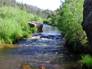 Kennedy Meadows is a good stop-off point as it has a restaurant, store, and camping facilities. The Pacific Crest Trail follows the river canyon with side routes to the river. Along this stretch of river , you’ll find
Fishing Maps AvailableSouth Fork Kern 3&4, Kennedy Meadows Covers the water of Kennedy Meadows. Shows camping areas, trails, and creeks. Special Features are the Hatch Chart, Fish Identification, Fishing Season and Regulations, and Stream Etiquette guidelines. | 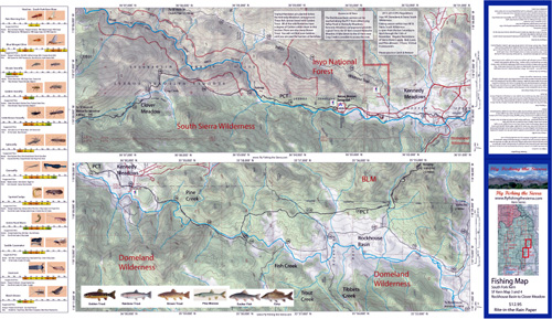 | $12.95 eaPurchase Here |