Notes:
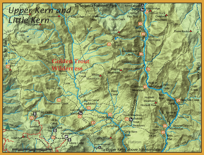
The upper reaches of Little Kern River is the home to the Little Kern Golden. Due to introductions of Browns, Brookies, and Rainbows into this watershed, the Little Kern Golden was on the edge of extinction with less than 5,000 in existence within 11 miles of stream above the confluence of Rifle Creek. Starting in 1975, DFG began a concerted effort to barricade any fish from entering this watershed above Rifle Creek and utilized a program to eradicate the introduced fish below the barrier. A barrier was built about one mile below Trout Meadows Creek to establish a critical habitat for the Little Kern Golden. Genetically pure strains of Little Kern Golden were replanted into the watershed above Trout Meadows Creek. Today, the Little Kern Goldens inhabit about 80 miles of stream. Below Trout Meadows Creek, the Little Kern River has a good population of Kern River Rainbows. There continue to be residual populations of both rainbows and browns within the watershed below Rifle Creek. DFG has built a total of 8 barriers within the watershed and will continue an eradication program of non-native species. A major concern is the presence of Rainbows which could cross-breed with the Goldens.
From the Lewis Camp trailhead (elevation 7600 feet), you can reach the Little Kern directly on the Lewis Camp Trail to the bridge crossing ( elevation 5600 feet) which is 4.5 miles distance. The Lewis Camp Trail is named for “Lewis Camp” which no longer exists but was located where the Kern Canyon Ranger Station is today. The trail reaches the Little Kern Bridge in 4.1 miles from the trailhead. Within this section of the Little Kern River are Little Kern Goldens. This is about 5.5 miles above the Forks of the Kern. Kern River Rainbows can only get up to about 2 miles above the confluence with the main Kern River where natural barriers on the Little Kern river inhibit further ingress and a man-made barrier was built 1 mile below the confluence of Trout Meadows Creek. The Little Kern is a freestone stream on both sides of the bridge with boulders and gravel. As you proceed downstream the river enters a canyon with steep, scoured walls and solid rock bottoms. This section has numerous deep pools with thin waterfalls dividing the pools during the summer months. Above the bridge, the river is more accessible with a freestone stream and heavy boulders. There are some canyon sections but less pronounced than below the bridge. This section also holds Little Kern Goldens.
From the Lewis Camp Trailhead, at 1.5 miles the trail intersects with the Jerkey Meadow Trail heading north to Grey Meadow. The trail heads down the north slope about 2 miles to Fish Creek.
Fish Creek : This creek is about 4 miles long with an elevation gradient of 1800′. The creek meets the Little Kern River at 5800′ elevation. This was one of only 5 creeks within the Little Kern watershed that had genetically pure Little Kern Goldens in 1973.
From the Clicks Creek Trailhead, you can follow Clicks Creek down to the Little Kern River.
Clicks Creek : This creek is about 5 miles long with a 1700′ gradient down to the Little Kern river at 6000′ elevation. The confluence is near Burnt Corral Meadows. The headwaters of Clicks Creek was found to have resident pure strains of Little Kern Goldens. The creek starts within a headwater meadow, then flows down a steep gradient as a freestone stream with numerous plunge pools. This area is difficult to fish due to terrain and vegetative cover. The creek reaches another meadow section about 1.5 miles downstream of the trailhead. Then plunges down another steep gradient another 1.5 miles until it reaches an area in which the trail spurs. The eastern spur trail goes to Grey Meadow Ranger Station and the northern spur goes to Burnt Meadow. The creek as a gradual slope to the Little Kern and you must follow the creek through a small canyon gorge to reach the river. Consists of Little Kern Goldens.
Soda Spring Creek : This creek is also best reached from the Clicks Creek Trailhead. Consists of Little Kern Goldens. It is 4 miles to Burnt Corral Meadow. Then another 4 miles to Nelson Cabin at Soda Spring Creek. The upper reaches of Soda Spring Creek was one of the last vestiges of pure-strain Little Kern Goldens found in 1965. The DFG used explosives at the mouth of Soda Spring Creek to prevent upstream migration of non-native fish.
The Summit Trailhead provides a direct route to some of the few natural lakes within the Southern Sierra. Since glaciation was not as pronounced as the central regions of the Sierra and the elevations of the crest steeply decline, there are few glacial lakes within this region. The three Maggie Lakes (upper, mIddle, and lower), Frog Lakes, and Twin Lakes all lie within a glacial cirque with drainage through Pecks Canyon that connects with Alpine Creek. Lower Maggie Lake is 9 miles from the Summit trailhead. The Maggie Lakes have Golden-Rainbow Hybrids in the 8-10 inch range.Upper and Middle Maggie Lakes are fairly shallow and were completely dry during the drought of 2015. The lakes are recovering with the better fishing at Lower Maggie. Frog Lakes and Twin Lakes are also shallow and devoid of fish.
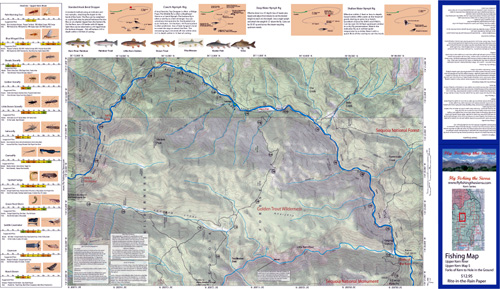
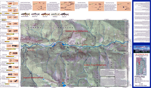
The Upper Kern River within the Golden Trout Wilderness is designated as a “Wild and Scenic” river by the State of California. It has one of the few remaining native trout for California streams in the Kern River Rainbow. Much of it’s genetic integrity has been protected by the natural barrier of a waterfall just above the confluence of Ninemile Creek, keeping the stocked Rainbows from below Johnsondale bridge from reaching these fish. The State has also designated a 45 mile portion of the Kern as one of 6 Heritage Trout Waters, which starts at the Forks of the Kern and ends at Tyndall Creek. Genetic testing has found that those Rainbows below the confluence of Durwood Creek have interbred with stockers. Kern River Rainbows are not the only trout to be found in the Heritage Trout waters. There are also some Browns and a small number of brookies.
From the Lewis Camp Trailhead, follow the Lewis Camp Trail to Trout Meadows and take the Doe Meadows trail (33E10) to the Kern River Trail at Kern Flat. This is about 12 miles from the trailhead. A couple of established campsites are available at the flat. The river in this section has large riffle areas, some pools, and lots of runs. A footbridge is at the northern section of the Flat and provides access to the eastern side of the river. It was in this area that the Old Jordan Trail also crossed the Kern and the trail continues onto Jordan Hot Springs. This section has primarily Kern River Rainbows 12-16″. Following the Kern River Trail upstream, 3.2 miles from Kern Flat, you reach the end of the trail at Painter Camp, which is on the eastern side of the river consisting of an old cabin and corral. If you can cross the river at this area, the eastern trail goes up to a canyon along the river near Hells Hole and the trail ends. Taking the River Trail downstream 6 miles from Kern Flat is the Forks of the Kern.
Taking the Lewis Camp Trail from Trout Meadows, you proceed northerly for 6 miles and reach the Kern River near Hell for Sure. A spur trail heads downstream to an area called Hole in the Ground. Hole in the Ground has a lot of riffle water near the end of the trail. The trail cannot go further downstream due to the canyon walls. During late Summer or during drought years you can wet wade into this canyon and reach Hells Hole. An interesting pool is near the spur intersection. The Kern meets a rock wall in which half of the water moves past downstream and the other half is diverted to the westerly side of the wall creating a 360 degree eddy. At the base of the wall, the depth is over 10 feet. A sand bar exists within the middle of this pool allowing a 360 degree drift for the angler. This stretch of the river has Kern River Rainbows 14-18″.
Following the Lewis Camp Trail upriver from the spur intersection to Hole in the Ground, you reach Grasshopper Flat, 7 miles from Trout Meadows. Grasshopper Flat is a freestone stream with plenty of boulders, riffles, and small pools. This is a popular section to fish with Kern River Rainbows 14-16″. At the northerly end of Grasshopper Flat the river is within a steep canyon section and the trail goes up a steep incline called the Devil’s Staircase. It proceeds down again into the Little Kern Lake.
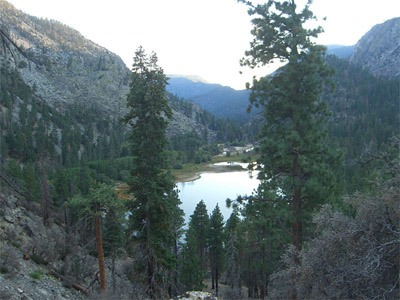
Little Kern Lake: Elevation 6200 feet. Consists of Kern River Rainbows and Browns. From Lewis Camp Trailhead, it is a 17 mile hike. The lake came about from a landslide that occurred during the 1860’s, which dammed the Kern River. The lake has some steep dropoffs in which the trout cruise along the shoreline. Most of the rainbows are 8-10 inches but some of the browns can get up to 4 lbs.
Kern Lake: Elevation 6225 feet. Consists mostly of Kern River Rainbows and Browns with some Goldens and Brookies. It is about .8 miles past Little Kern Lake. At one time, prior to 1978, Kern Lake was used as a fish nursery for Kern River Rainbows with the spawn allowed to rear within the lake prior to being introduced to the river.
About 1/2 mile upstream of Kern Lake is a camp area where the Kern becomes a slower moving water with a deep run. From this area up to the Kern Canyon Ranger Station, the Kern River Rainbows have many different structures to reside. The water has riffles, runs, deep pools, plenty of boulders, and log structures. The Kern River Rainbows can reach up to 18″ or more within this stretch. There are also a large number of Brown trout in the 16-20 inch range. This section is often considered a “world-class” fishery.
|
| Fishing RegulationsKern River from Johnsondale Bridge to Sequoia National Park boundary: Open all year. Only artificial lures may be used. 2 trout. Little Kern River: Open all year. Only artificial lures may be used. 2 trout. Golden Trout Wilderness Area (Tulare Co.), excluding the main stem Kern River: Open all year. Only artificial lures may be used. 2 trout. Other Rivers and Streams: Open all year. Only artificial lures may be used. 2 trout. All other Lakes: Open all year. No restrictions. 5 trout per day. 10 trout in possession. |