
Types of Lakes | |||
Lakes are often described within a classification sysytem developed around natural forming lakes: the Oligotrophic, Mesotrophic, Eutrophic, and Dystrophic types. The Oligotrophic types consists of the young Alpine and Glacial lakes where the lake bottom is strewn with boulders and rocks. The Mesotropic types are somewhat older with rock and gravel forming the bottom, having an abundance of aquatic insects as well as plant life. Spring-fed lakes are often this type. The Eutropic types are even older yet and will have the addition of sand and mud to the bottom. The Eastern Alkaline lakes are often of this type. Keep in mind, however, that many of the Sierran lakes, particularly in mid- and low-elevations, are of artificial derivation. Often, these natural classifications cannot apply to the artificial lakes that are created by dams as the natural biota have not had adequate time to adjust to the newly-formed stillwaters. These reservoirs are also programed by water management guidelines that have a great impact on both the invertibrates and the fish as water levels change drastically. So, I've delineated the Sierran lakes into categories that you can readily identify. Each of these categories have their own characteristics and require particular tactics for flyfishing :
| |||
Eastern Slope Alkaline Lakes | |||
|
Eastern Slope Alkaline Lakes are below 10,000 ele. with a pH of 7.5 to 9.5, which is an optimum pH for fish habitat. They are located in arid semi-desert environments along the eastern slope of the Sierras. Scrub, Sage, and Pinon Pines are usually found around their shores. They are high in nutrients with shallow flat feeding areas and extensive weedbeds. The high pH increases the clarity of the water and sunlight is able to penetrate up to 40-50 feet, increasing weedbed activity. The lake bottom is volcanic in origin with plenty of mud and silt. Usually spring creeks are associated with the lakes supplying cool, highly mineralized water. The lakes will have seasonal algea blooms as the temperatures rise during the summer. The fish are usually Rainbows and Browns that will generally feed upon a resident food supply of leeches, snails, scuds, and baitfish. Intensive hatches will also occur such as Chironomids and Damselflies. The lakes are ice-free from May through November allowing for a longer growth period for the fish.. | |||
Low-Elevation Reservoirs | |||
|
Low-Elevation Reservoirs are between 2,000 and 4,000 ele. They are generally along the Western slopes of the Sierras associated with Digger Pine, Scrub, Ponderosa Pine, and Oaks. The reservoirs are fed by major freestone streams and rivers originating from snowpack areas of the higher elevations. These reservoirs have dams and are subject to high fluctuations in water levels depending upon water and power needs. These reservoirs are usually deep with flat areas at the stream inlets. The lake bottoms are usually a mixture of rock, mud, and silt. The fish are Rainbows, Browns, Crappie, Carp, and Largemouth Bass. The fish will feed on baitfish as well as transitional insect hatches. The lakes are ice-free year round and usually open to fishing year round. | |||
Mid-Elevation Reservoirs | |||
|
Mid-Elevation Reservoirs are between 4,000 and 10,000 ele. They are found on either side of the Sierras and are associated within a temperate forest environment of Mixed Conifers or Ponderosa Pine on the Western slopes and Jeffrey Pine on the Eastern Slopes. Most of these reservoirs are created by dams along major stream and tributaries. They are deep with rocky bottoms and canyon slopes. They have smaller feeding flats located at the the stream inlets. The fish are usually Rainbows, Browns, and Brookies feeding upon the transitional insect hatches. The lakes are ice-free from June through November. | |||
Mid-Elevation Glacial Lakes | |||
|
Many of the natural lakes in the Sierra Nevada over 6000' elevation were made through glacial activity during the Ice Age. Expansion and contraction of the ice left depressions within the rock as well as forming sand and gravel. Much of the debris from a glacier created large moraines which acted as a natural dam in forming a lake behind it. Many of these moraine structures will occur in steps so that a number of lakes will result in a step-like formation or a chain of lakes. Above 10,000 feet elevation most of the geologic material is recent and the bottoms of these lakes will be relatively sterile in organic matter, slightly acidic, with little dissolved nutrients. I've grouped these particular lakes as Alpine Lakes. Below 10,000 feet, there will be some turf or soil is around the lake and the chances are better that there will be improved habitat for the trout. These are the mid-elevation Glacial Lakes. | |||
Spring-fed Lakes | |||
|
Spring-fed Lakes are between 4,000 and 10,000 ele. with a pH of 7.0 to 8.0 . They lie within the same forest environment as mid-elevation reservoirs. Rather than being fed by major streams and tributaries, these lakes recieve much of their water from Springs and Spring Creeks. The bottoms can be a mixture of rock, gravel, and mud. The depths of the lake will vary but will have clear water with little algea. The fish are Rainbows, Browns, and Brookies feeding upon baitfish and transitional Insect hatches. The lakes are ice-free from June to November. | |||
Alpine Lakes | |||
|
Alpine Lakes are usually above 10,000 ele. with a pH of less than 7.0 These waters have been historically devoid of fish within the Sierra Nevada due to geologic uplift that made the streams to difficult for fish to navigate in order to reach these lakes. Since the early 1900's, artificial stocking has achieved about 80% stocking to most of these waters. Many of the Alpine lakes are low in nutrients with rocky, granitic bottoms and shallow depths. There are some Alpine Lakes that are found within volcanic regions and these tend to have higher nutrient levels due to a higher pH. The fish will be much larger within these lakes. | |||
Lake Cycles | |||
There are eight general changes throughout the year which affect Sierran Lakes and how they are fished. Together, these changes
represent a cycle. Not all of these changes occur to every lake. For instance, low elevation reservoirs will not freeze-up nor have a
corresponding ice-out. These reservoirs may not even have a Fall Turnover despite having similar temperatures throughout the depths.
| |||
Ice-out | |||
During Ice-out, warmer air temperatures will melt the edges of the ice along the shorelines. The melted water enhances weed growth within shallow areas providing both shelter to forage food, such as minnows, and oxygenated water from the photosynthesis of the weeds. Trout will come to these shallow areas for short periods of time from the protected cover of the ice sheets that lie over the deeper sections of the lake. Spawning will often occur during this time period and the trout will stack up within the inlets and outlets seeking the highly oxygenated water of the streams. As the water warms up and the ice recedes, certain insect hatching activity takes place such as chironomids, cased caddis, and dragonfly nymphs. | |||
Spring Turnover | |||
When the surface temperature of the water reaches 39 degrees Farenheit, the lake will turnover. This creates a turbid condition with sediment from the bottom clouding the entire water column. Fishing is usually poor during this period. The period usually lasts for only 1-2 weeks when sediment settles again and the water column has the same temperature and dissolved oxygen content. | |||
Second Warming | |||
A second warming occurs after turnover. The shallows become warmer and and the water becomes clearer. The fish are still sluggish from the sub-forty degree water and presentations must be slow to provoke actions from the trout. Chironomids usually start showing a lot of activity on the bottom at this time since the oxygen content is high after turnover. The trout will often feed upon the active chironomids at these depths for weeks prior to any ascending hatch activity. | |||
Stratification | |||
As the surface temperatures of the lake warm, the lake will stratify into two temperature zones separated by the thermocline. The upper zone is known as the Eplimnion which is warmed by sunlight and air temperatures. Wind action will help churn this layer to greater depths. The bottom zone is the Hypolimnion which is the colder water that sits at the bottom of the lake. The bottom of the lake will never be less than 39.2 degrees since this is the temperature in which water reaches it's maximum density. Thermoclines usually have temperatures of 44-50 degrees and they are defined by a rule that they have a half degree change every foot of depth. The trout will tend to seek those areas with the right temperature requirements and areas that provide both cover and forage. Often, this will be within a middle depth feeding area. Daphnia blooms will often occur within these depths and the trout will feed upon them exclusively. This can go on for about 2-3 weeks. | |||
Descending Thermocline | |||
As the surface continues to warm up, the warmer surface temperatures will push the thermocline downwards. Oxygen levels in the shallow areas will decrease as the water heats up, so that the trout will only explore these areas during the early morning hours. During the day, the trout will seek deeper depths where they can find forage yet remain within a comfortable zone of temperature and oxygen, just below the Thermocline. At some time, the thermocline reaches the lake bottom and the water becomes iso-thermal. This is usually the period of the summer doldrums where the trout are lethargic due to the lack of oxygen. Most of the fish seek underwater springs and inlet areas. Thunderstorms will bring increased fishing activity by injecting oxygen back into the lakes ecosystem. Wind will also help create subsurface currents bringing zooplankton to the surface. | |||
Fall Cooling | |||
Sometime, around mid-September, the thermocline disappears and the surface water becomes cooler. Often the shallow sections will cool and the minnows will become quite active within the weedbeds encouraging trout to feed within these areas. The fishing improves every day right up to Fall Turnover. | |||
Fall Turnover | |||
When the water at the surface cools , it increases in density. At some point when the density of the surface water equals the density of deeper waters, it will turnover with the warmer waters below and achieve an iso-thermal condition in which all the water column are of equal temperature. The fish will often feed exclusively within the shallow, shoreline areas during this time until freeze-up. | |||
Freeze-up | |||
During Freeze-up, surface water temperatures reach 32 degrees farenheit and will create a ice sheet layer over the lake's surface. The trout will become sluggish and reside within the deeper, warmer zones of the lake. | |||
Reading Water | |||
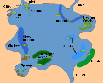 | |||
There are three main factors that fish seek within lakes:
Certain physical characteristics of the lake will determine how the fish are able to meet these three needs. If you can identify the physical charcteristics of a lake and understand the needs of the fish, you can get a good understanding of where the fish will be throughout the year. Ron Newman, "Rainbow Trout Fly Fishing-a Guide for Stillwaters", cites that 50% of the trout are caught within the shoals and another 30% are caught at the drop-offs. His point is that the fish remain within the shallow zones of the lake where plant life and food are abundant. | |||
Inlets | |||
|
Inlets bring both food and cooler, oxygenated water into a lake. Fish will usually congregate in front of an inlet waiting for the food to come to them within the inlet current. Many fish will also use the inlets for passage into the stream for spawning. Inlet bottoms are usually shallow with an alluvial base of sand and gravel but larger stream inlets tend to cut a channel that extends into the lake. These channels provide shelter for the fish. Approach inlets with care, the fish tend to be wary since the inlet provides less shelter than elsewhere within the lake. Terrestrials such as beetles, hoppers, ants work well as a dry presentation. Many nymph patterns also work well. Drag-free presentations are a must and inlets will provide an additional presentation problem in that the current is bounded by calm water on both sides. Streamers work well, too, since many smaller baitfish seem to congregate around inlet areas. | |||
Springs | |||
Springs provide both oxygen and water at a stable temperature throughout the year. It is probably the most consistent area that you will locate fish within a lake. Springs can be very important to fish survival in Alpine Lakes. They maintain oxygen deprivation and keep the lakes from freezing solid in the Winter. During the early Spring, these areas tend to be warmer than the surrounding waters and the fish will congregate within. During the mid- to late Summer months, as the lake waters warm, fish will also seek out springs for cooler, more oxygenated water. Springs tend to generate a good habitat for weed growth, which will generate a food source through other aquatic animals. Basically, springs are the "Edens" of fish. | |||
Shallows and Shoals | |||
Shallows are generally thought of as less than 10 feet in depth. Shoals are shallow areas surrounded by deeper water. Shallows are important areas since they represent areas of organic accumulation, good light penetration, and weedbed habitat that create an environment for food. Fish will explore these shallow areas, particularly during low-light conditions, to feed upon insects, crustaceans, and baitfish. Shoals have an added attraction to fish since the drop-offs around them provide a source of shelter. Shallows and Shoals tend to be the first areas of the lake to warm up in the Spring and fish will be attracted to these areas from a temperature/oxygen comfort level. Shallows and shoals come about through erosion of shoreline banks and sediments carried by inlet streams. Generally, those lakes with irregular shorelines, lots of bays, and gradual sloping banks will have more shallows associated to them. Most Shallow and Shoal areas are fished with either floating or Type I Intermediate lines with a sink rate of 1-2 inches per second. The clear lines are often your best choice within these areas. The Type 1 line will allow for a gradual sloping retrieve that is similar to the emergence swims of mayfly and damsel nymphs, and caddis pupae. Count down the rate descent of the line to get the fly to the proper depth before using retrieval techniques. | |||
Drop-offs | |||
Drop-offs are abrupt depth changes to the lake bottom. They are the transition zone between the deep and shallow areas of the lake. Usually, they are found in 15-25 feet in depth. Drop-offs can be along shoals, the edges of submerged channels, and along the edges of shallow areas. You can usually see the drop-offs visually by the change in water color to a deeper hue. Drop-offs are important areas for fish to find shelter. They will usually be in these areas during the mid-day and will only venture out during low-light conditions. The best drop-offs are those that have a gradual slope. Gradual slopes will allow for more abundant habitat of rooted vegetation than a steep drop-off. This type of habitat usually supports scuds, midges, caddisflies, damselflies, dragonflies, mayflies, and leeches. A number of fishing tactics employ the use of drop-offs. Some will troll a streamer along the contours of the drop-off, such as a woolly bugger or leech pattern. Others will cast a streamer perpendicular to a drop-off, let it settle, and retrieve the streamer with a sweep up the drop-off to the shallow flat. A lift and settle nymphing technique will also produce good results during certain hatching periods, particularly callibaetis. Another good technique is the Wind Drift tactic with a floating line and leader length adjusted to the depth desired. A slight breeze will blow the fly down or parallel to the drop-off. Trout will see the fly as a fleeing food source and will often strike hard. Also try a Count and Retrieve technique with an intermediate line, particularly with leeches, caddis pupae, and damselfly nymphs. Count the descent so the the retrieval is made close to the bottom. | |||
Deep Water | |||
Deep Water areas are generally those that exceed 35 feet. Chironomids are known to emerge from depths up to 60 feet, so some of these areas can become the choice habitat for trout especially during the hotter midsummer months. The depth provides protection, cooler temperatures, and a food source. Use a type 6 or 7 sinking line with a rate of 6-9 inches per second to get the fly to the proper depth. Once off the bottom, a pupal chironomid pattern can be retrieved vertically to imitate a natural ascension or allowed to remain at the bottom, with a twitching motion, that will keep the fly within a foot or two of the bottom to imitate the pre-emergent staging that occurs with chironomids. Trout will also inhabit deep water areas below schools of baitfish. Use a streamer pattern with a type 6 or 7 line and count down the rate of descent to get the fly below the baitfish and allow for a vertical retrieve. | |||
Weedbeds | |||
Weedbeds usually indicate a healthy habitat of food and shelter for fish. Weeds can be submerged or at the surface. With many of our Sierran reservoirs, the water levels fluctuate throughout the season based upon water need and future storage capacity. These fluctuations affect the amount of light penetration to weedbeed areas and influence how they form, the depth of the weedbeds, and their seasonal disappearance. Damselfly nymphs are particularly important around weedbed areas, presentations are made using a floating line with a leader length that keeps the damsel nymph above the weedbed height. A slow-sinking intermediate line is often used with streamer patterns using a count down and retrieve technique. The streamer is either pulled over the weedbeds or allowed to settle into the weed channels before retrieval. | |||
Foamlines | |||
Foamlines show up during windy conditions. The foam will act like a fly paper and capture many terrestrial insects that get blown by the wind. Fish will utilize the foamline as both cover and a source for food. They will pick-off the trapped insects from below the foamline. When foamlines are present, try casting foam ants, hoppers, and beetles into the foamlines. | |||
Shoreline Structures | |||
Shoreline structures can be cliffs, brush and trees, tree stumps, boulders, and any other type of structure that influences shelter, temperature, and food sources for the fish. Fish will often place themselves along the walls of cliffs that edge the shoreline. They provide a shaded, cool area of water during certain times of the day depending uponthe aspect of the cliff. They are also sources of food when insects are blown against the walls of the cliff and fall to the water. Boulders that line the shores can be microcosms of cliffs. Many crawling nymphs will migrate to these structures to climb out and hatch. The fish will pick these insects off during the migration. Brush and Trees also provide cooler water and shelter for fish. Many terrestrials will fall from the foliage to the water below. Often, you will need a float tube to reach these areas since they are too dense to reach from shore and the fish tend to spook easily when approached from shore. | |||
Outlets | |||
Outlets are areas in which the lake loses water to a downhill stream. They tend to be shallow, but do offer a food source by funneling insects into a constricted area. Fish tend to shy away from outlets during the day due to exposure but may use the area for feeding during the night. | |||
Approaching a Lake | |||
Upon approaching a lake, consider the category of water it is. Take note of the structure and time of year concerning insect hatches. If there are no fish within the shallows, I often use a streamer pattern with an intermediate line or Type 1 Sinking line to explore areas and depths where fish might lie. First, bring the streamer along drop-offs, submerged weed channels, within springs, and shoals. Once a fish has been caught, inspect the stomach contents with a probe and analyze the contents. This will often key you to the proper fly to select. Watch the water for insect activity and for rises that are occurring. Remember that feeding changes through the day. A damselfly hatch in the morning may give way to a Chironomid hatch in early afternoon. The fish have ample time to inspect their food, so your patterns need to be near perfect. Pay close attention to size, color, and movement of the fly. As the day proceeds and the surface temperatures get warmer, the fish will migrate to deeper waters. Presentation is critical in successful fishing within lakes. Select the proper rod, line, and leader. Within deep water, you'll want a stiff 9 foot 7 weight rod with fast action to pick up the full sinking line off the water. Within shallower water, you might prefer a shorter, softer rod such as a 8' 6" Med.action, 5 or 6 weight, that will handle a floating line and allow for better turn-over of lighter leaders. The soft action may be critical in keeping the tippet from snapping on an aggressive hit at the surface. Within lakes, the fish move around to find food. This is quite different from a stream environment where the fish choose feeding stations and the food comes to them. Find the food source and you'll find the fish! | |||